Narrabeen, NSW
Located on the Northern Beaches of Sydney, Narrabeen Beach is a coastal paradise offering an idyllic blend of natural beauty, oceanic activities, and a thriving local culture. Encompassing a 3.6 km stretch of golden sands, it’s a haven for both local residents and visitors from around the world.
Known For:
- Great surf beach
- Relaxed coastal suburb
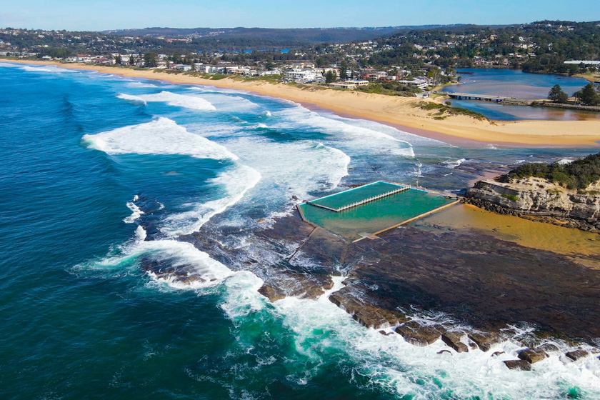
The strip of sand is actually four beaches. The surf clubs mark the progression from Collaroy to South Narrabeen, Narrabeen and North Narrabeen.
Featuring a stunning coastline flanked by rock pools at both ends, Narrabeen Beach is divided into North and South Narrabeen. The beach is famed for its excellent surf conditions and holds a significant place in Australia’s surfing culture. Narrabeen is also one of the few beaches in the area that allows off-leash dogs, so it’s great for visitors traveling with their furry friends.
Aside from the obvious sunbathing and beach relaxation, there are plenty of activities to enjoy at Narrabeen Beach. Surfing is big here, with the beach regularly hosting surfing competitions. There’s a surf school for beginners and plenty of surf shops around for gear and advice.
If you’re a fan of water sports, there’s also windsurfing and paddleboarding to enjoy on the Narrabeen Lagoon. Anglers can try their luck at catching a variety of fish species, and the rock pools at the ends of the beach are perfect for those with small children or anyone interested in exploring the local marine life.
Walking and cycling enthusiasts will love the Narrabeen Lagoon Trail, a stunning 8.4 km circuit that takes you around the tranquil Narrabeen Lagoon, with picturesque views and plenty of wildlife spotting opportunities.
Narrabeen Beach is host to several annual events such as the Carols by the Sea in December and the Australia Day Celebrations in January, adding to the vibrant community spirit that this place is known for.
Eat and Drink
After a long day at the beach, you’ll be spoiled for choice when it comes to dining options. The area boasts a selection of cafes, restaurants, and takeaways, offering everything from fresh seafood and hearty burgers to healthy salads and smoothie bowls. The casual beachfront eateries provide incredible views to accompany your meal.
The culinary scene in Narrabeen offers a delightful array of beachside eateries, cosy cafes, and superb restaurants serving a variety of cuisine. Here are a few of the best ones to consider during your visit:
The Boatshed Cafe & Bar
Perched on the edge of the serene Narrabeen Lagoon, The Boatshed Cafe & Bar offers stunning waterside views, a relaxed ambience, and a delectable menu. Serving up modern Australian fare, the restaurant is especially popular for its fresh seafood dishes. Don’t miss their weekend breakfast menu and make sure to try their selection of artisanal cocktails.
Oceans Narrabeen
Oceans Narrabeen is a favourite amongst locals and tourists alike, known for its beachfront location and delicious food. Their menu features a variety of dishes, including the beloved fish and chips, gourmet burgers, and a fine selection of fresh salads. With a casual, laid-back atmosphere, it’s the perfect place for a relaxed lunch or dinner after a day at the beach.
Mexicano
If you’re in the mood for some mouth-watering Mexican cuisine, Mexicano is the place to go. Famous for its vibrant atmosphere and authentic dishes, this restaurant offers everything from enchiladas and tacos to ceviche and grilled meats. Their cocktails, particularly the Margaritas, are well worth trying.
Cafe Zee
This charming cafe is perfect for a morning coffee or a leisurely brunch. Cafe Zee offers a variety of breakfast and lunch options, including sandwiches, salads, and some deliciously sweet treats. Their coffee is also highly praised, making it a must-visit spot for caffeine enthusiasts.
Thai Riffic on the Beach
For lovers of Thai cuisine, Thai Riffic on the Beach offers an array of traditional Thai dishes with a modern twist. The restaurant features a stunning interior and beach views that complement the spicy and aromatic dishes. Don’t miss their Pad Thai or the Green Curry.
The Sands Hotel
The Sands Hotel is not only a great place for accommodation but also boasts a fantastic restaurant. The menu offers a range of Australian classics, including a variety of pizzas, burgers, and steaks. It’s also a great place for a sundowner, with a good range of local and imported beers, wines, and spirits.
Each of these places adds to the culinary charm of Narrabeen, offering a taste of local and international flavours while embracing the laid-back beachside lifestyle of this coastal suburb.
Where To Stay
There’s a range of accommodation options around Narrabeen Beach to suit every budget, from luxury resorts and boutique hotels to budget-friendly hostels and holiday parks. Many places offer incredible beachfront views and easy access to the beach and surrounding attractions.
Getting There
Located around 23 km northeast of the Sydney central business district, Narrabeen Beach can be easily reached by car, bus or taxi. Public transport is an excellent choice with regular bus services operating from the city centre. The journey allows you to enjoy the stunning coastal vistas and lush greenery as you move closer to your beach destination. The Narrabeen SLSC lies opposite grand old Furlough House on Ocean Street, across a stretch of land that has been made into a large park with picnic tables, a single barbecue, toilets and showers.
Features: Surf, toilets and showers
Where to stay?
Experiences
- Active
- Nature based
- Relaxation
Popular Activities
- Trail bike riding
- Canoeing
- Golfing
- Sightseeing
- Swimming
- Fishing
- Fishing - Beach
- Beach
- Surfing
- Seakayaking
- Snorkelling
About Narrabeen
- Locality: Suburb
- Narrabeen Postcode: 2101
- State: New South Wales
- Region: Sydney
- Latitude: -33.72313
- Longitude: 151.28737
- Elevation: 71m
- Population: 8207
- Median Income: $48932
- Area (Sq/km): 2.197
- Timezone: Australia/Sydney