
Babinda, QLD
Babinda is a small sugar town just off the Bruce Highway, 59 km south of Cairns, sitting at the foot of Queensland’s two highest mountains. It competes with Tully and Innisfail for the title of Australia’s wettest town, and all that rain feeds the rainforest creeks, swimming holes and waterfalls that bring most visitors here.
Known For
- The Babinda Boulders
- Josephine Falls and Mount Bartle Frere
- Rainfall of more than four metres a year
The town itself is quiet and unhurried, with a wide main street of timber pubs and Art Deco shopfronts backed by cane fields and cloud-capped ranges. Mount Bartle Frere (1,622 m) and Mount Bellenden Ker (1,593 m) rise directly behind it, both inside Wooroonooran National Park and the Wet Tropics World Heritage Area. Babinda averages around 4,500 mm of rain a year, most of it between December and April, so come prepared for a downpour at any time.
Things To Do
Babinda Boulders
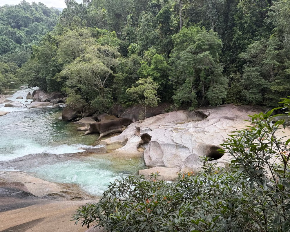
Six kilometres west of town, Babinda Creek runs clear and cold out of the mountains through a jumble of huge granite boulders worn smooth by the water. There is a large, calm swimming hole beside the picnic area, and the Devils Pool Walk, an easy 1.3 km return track, leads downstream through rainforest to lookouts over the chutes and pools below. Swim only in the signposted area. The water further down is fast and deceptive and has taken many lives. The place is significant to the Yidinji people, whose story of the young woman Oolana explains the danger of these waters.
Josephine Falls
About 20 minutes south of Babinda, a 700-metre track through dense rainforest leads to one of the most photographed waterfalls in north Queensland, where Josephine Creek tumbles over granite slabs into a series of pools. Swimming is allowed in the lower pool. The creek can rise very quickly after rain, so heed the warning signs.
Mount Bartle Frere
The summit trail to Queensland’s highest peak begins at the Josephine Falls car park. It is a steep, demanding 15 km return climb that takes experienced walkers a very long day, and many camp overnight. The top is often in cloud.
Bramston Beach and Eubenangee Swamp
A 20-minute drive east through cane fields leads to Bramston Beach, a long, quiet, palm-lined beach with a small campground. On the way, Eubenangee Swamp National Park has a short walk to a grassy hill overlooking wetlands that are home to a wide range of waterbirds, and to crocodiles.
Babinda State Hotel
The hotel on Munro Street was built by the Queensland Government in 1917, in part to stamp out sly grog selling among cane workers, and is said to be the only pub in the state ever built by the government. Its sale was approved by Parliament in 1929, it passed into private hands in 1930, and it is still trading.
Kayaking Babinda Creek
Babinda Kayaking hires single and double kayaks and stand-up paddleboards for a self-guided float down Babinda Creek, a clear mountain stream with turtles, fish and sometimes platypus, a few small rapids and sandy spots to stop for lunch and a swim. They pick up the kayaks at the end and take you back to your car. It runs Thursday to Sunday and on public holidays, and bookings are essential. Dogs are welcome.
The Goldfield Trail
The 19 km Goldfield Trail, an old miners’ route, crosses the range from the Babinda Boulders to the Goldsborough Valley, with creek and river crossings, steep sections and a camp site at a causeway about halfway. Walkers usually allow seven to nine hours one way and arrange a car shuffle; the first half from the Goldsborough end is also open to mountain bikes. There is no tap water at the Goldsborough Valley end until January 2027, so carry plenty.
History
Babinda is on the country of the Wanyurr Yidinji people. The town’s name is thought to come from a Yidinji word, often translated as water passing over your shoulder, or simply as a word for rain or waterfall.
European settlement followed the timber-getters, who came for red cedar in the 1880s, and then the cane farmers. The Babinda Central Mill began crushing in 1915 and the town grew around it. A cyclone in 1918 destroyed much of the young settlement, and the rebuilding that followed gave the main street its 1920s and 1930s character.
The sugar mill closed in 2011 after almost a century, and local cane is now sent to mills elsewhere. Cyclone Larry in 2006 and Cyclone Yasi in 2011 both caused serious damage in the district.
Where To Stay
Accommodation in Babinda is modest: pub rooms, a motel and a few cabins and holiday houses in the surrounding valleys.
Campers are well catered for. There is a free campground beside the creek at the Boulders, with a short maximum stay, and a free camping area at Rotary Park in town, with a dump point and coin-operated hot showers, that is popular with caravanners. Bramston Beach also has a council campground. For resorts and a wider choice of hotels, base yourself in Cairns or Mission Beach.
Babinda is a CMCA RV Friendly Town, and both free camps run on a 72-hour limit with no bookings. Rotary Park on Howard Kennedy Drive, a short walk from Munro Street, takes caravans, motorhomes, campervans and tents and has the town’s dump point, toilets, coin-operated hot showers, barbecues and sheltered tables; there is no power, and dogs are allowed. The Boulders camping area at the end of Boulders Road, 6 km from town, has large sites, toilets, cold showers and barbecues a short walk from the swimming hole, but no dogs. The Babinda State Hotel on Munro Street has ensuite rooms sleeping two to four, the simplest bed in town.
Bramston Beach Council Campground, about 25 km away at 96 Evans Road, has powered and unpowered sites booked through the caretakers, with stays of up to 12 weeks and peak rates at Easter, in school holidays and from July to October. Fishery Falls Holiday Park, about 28 km north, has cabins and powered sites, and the Garradunga Hotel, about 20 km south near Innisfail, offers free unpowered and low-cost powered camping behind the pub (no showers). Ulysses Laundromat on Mill Street is handy for travellers.
Eat & Drink
Munro Street has a well-known bakery, a couple of cafes, takeaways and the pubs, which serve counter meals. Most places keep country hours and close early.
The picnic areas at the Boulders and Josephine Falls have tables and barbecues, so bringing lunch is a good plan.
Munro Street has more choice than its size suggests. The Babinda Independent Bakery at 35-37 Munro Street is the classic stop for pies, bread and picnic supplies on the way to the Boulders; it closes on Sunday and Monday. The Babinda State Hotel’s Bistro 1917 serves breakfast, lunch and dinner, eat in or take away, in the heritage-listed 1917 pub (closed Tuesday and Wednesday). Across the road, the Babinda Taverna and Amore Ristorante does Italian and Mediterranean food, including pizza and pasta, with a bottle shop, takeaway and live music.
Hey Mate Cafe at 47 Munro Street, open Thursday to Monday, is known for homemade sodas, iced yerba mate, cakes, savouries and toasted sandwiches, and Babinda Burgers and Froyo at 103 Munro Street does burgers and frozen yoghurt. Zenna’s General Store on Howard Kennedy Drive sells coffee, toasties, fresh sandwiches and wraps along with groceries, bait and ice. Fuel is at Zenna’s (open daily, shorter hours at weekends), and the Twin Rivers Roadhouse at Deeral, about 25 km north, has fuel and fish and chips from 5 am every day.
Getting There
Babinda is on the Bruce Highway, about 50 minutes south of Cairns and 25 minutes north of Innisfail. The town centre is a short detour off the highway.
Long-distance coaches and the Brisbane to Cairns train pass through, but the Boulders and Josephine Falls are out of town and need a car. Several day tours from Cairns include both.
Experiences
- Nature based
- Rural/Country
- Self-Drive
Popular Activities
- Bush Walking
- Caravan and Camping
- Kayaking
- National Park
- Rainforest
- Swimming
About Babinda
- Locality: Urban locality
- Babinda Postcode: 4861
- State: Queensland
- Region: Cairns & Great Barrier Reef
- Latitude: -17.34442
- Longitude: 145.92482
- Elevation: 12m
- Timezone: Australia/Brisbane
