
Millaa Millaa, QLD
Millaa Millaa is a small dairy town on the southern edge of the Atherton Tablelands, about 100 km south of Cairns and more than 800 metres above sea level. Known as the Village in the Mist, it is surrounded by steep green hills and rainforest gullies, and is the starting point for the Waterfall Circuit, a short drive taking in three of the prettiest falls in north Queensland.
Known For
- Millaa Millaa Falls and the Waterfall Circuit
- Rolling dairy country and cool mountain air
- The Palmerston Highway through World Heritage rainforest
The town has one wide main street, lined with flowering trees, and a climate quite unlike the coast: mild in summer, cold on winter nights and often wrapped in cloud. Most visitors come for the waterfalls and stay for an hour, but the district rewards a slower look, with lookouts, farm cafes and rainforest walks along the highway to Innisfail.
Things To Do
Millaa Millaa Falls
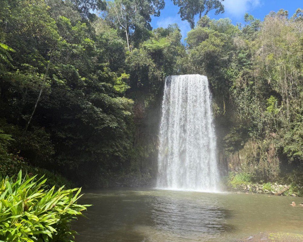
The best known of the three falls is a few minutes from town. Theresa Creek drops about 18 metres in a single curtain over a wall of basalt columns into a round pool ringed by tree ferns. It is among the most photographed waterfalls in Australia and one of the easiest to swim at, with a car park and picnic lawn right beside the water, and new amenities due once the council’s precinct upgrade is finished.
The Waterfall Circuit
The 17 km loop along Theresa Creek Road continues to Zillie Falls, viewed from a platform at the top, and Ellinjaa Falls, where a short track winds down to the base. Platypus and turtles are sometimes seen in the pools. The whole circuit takes about an hour without stops and is sealed all the way.
Millaa Millaa Lookout
West of town on the road to Ravenshoe, this lookout takes in a wide sweep of the southern Tablelands, with Mount Bartle Frere and Mount Bellenden Ker on the skyline on a clear day.
Town Walk and Museum
A stroll along Main Street passes the Eacham Historical Museum, which opens most mornings, the giant logs of an ancient kauri pine felled by a cyclone, and a bronze statue of the explorer Christie Palmerston with his Aboriginal companion Pompo.
Palmerston Highway
East of town the highway descends through Wooroonooran National Park. Short walks lead to Crawfords Lookout, Nandroya Falls and other cascades, and the Mamu Tropical Skywalk has an elevated walkway and tower through the rainforest canopy above the North Johnstone gorge.
Mungalli Falls and Pepina Falls
Two quieter falls make a good alternative while Millaa Millaa Falls is closed for works. Mungalli Falls, about 13 km from town via the Palmerston Highway and Junction Road, drops about 90 metres and is one of the highest on the Tablelands. Pepina Falls is about 10 km out on the Old Palmerston Highway at Middlebrook Creek, a short walk from roadside parking. The council says Zillie, Ellinjaa and Mungalli falls stay open every day during the upgrade.
Misty Mountains Wilderness Tracks
Millaa Millaa is a gateway to the Misty Mountains trails, more than 130 km of long-distance tracks through high-altitude rainforest between Millaa Millaa, Ravenshoe, Tully and Innisfail, built by the councils, Queensland Parks and Wildlife, Traditional Owners and volunteers. They suit fit, well-equipped walkers. Check QPWS alerts first: in November 2026 part of the Gorrell track (eastern trailhead) is closed until 27 November, and the southern Koolmoon Creek track (including Elizabeth Grant Falls) and part of the Cannabullen Creek track are closed until 18 December.
History
Millaa Millaa is on the country of the Mamu people. The name comes from their language and is thought to refer to a rainforest vine with edible fruit, though it is often translated as plenty of water.
In 1882 the bushman Christie Palmerston, guided by Aboriginal companions, found a route through 90 km of unbroken rainforest between the coast at what is now Innisfail and the tin town of Herberton. The highway that carries his name follows much the same line.
Settlers began clearing land in 1910 and the railway arrived in 1921. Timber came first, then dairying, with a butter factory opening in 1930. By 1960 there were about 130 dairy farms in the district. The railway closed in 1964 and the sawmill in 1987, and farms have since merged into fewer, larger holdings.
Where To Stay
The town has a hotel, a small motel and a caravan park with cabins.
Several farm stays, cottages and rainforest retreats are scattered through the surrounding hills, many with long views across the Tablelands. There is more choice at Malanda and Atherton, both within 40 minutes.
The Millaa Millaa Tourist Park, on the corner of Malanda Road and Lodge Avenue, sits in about 7 acres of rainforest gardens and takes caravans, campers, tents and backpackers, with cabins, a pool and a pet-friendly policy. It is listed by Tablelands tourism as an RV-access park, and it is the only caravan park in town, so book ahead in the cool, dry winter months when the Tablelands fill with southern travellers.
For national park camping, Henrietta Creek in the Palmerston section of Wooroonooran National Park is about 20 km east on the Palmerston Highway. It has 10 numbered grassy sites beside the creek, suits caravans and motorhomes, and must be booked with QPWS before you arrive. Malanda, about 24 km north, and Ravenshoe, about 25 km south-west, have more parks and motels.
Caravans: the Palmerston Highway from Innisfail is a sealed highway but long, steep and winding, so take it slowly; avoid the Gillies Range Road with a van and come up via Malanda or the Kennedy Highway instead. While the falls works continue there is no parking for caravans, trailers or oversized vehicles at Millaa Millaa Falls. The nearest public dump points are in Ravenshoe (26 Ascham Street) and Yungaburra (Mulgrave Road).
Eat & Drink
Main Street has a few cafes and the pub. The district is known for its dairy produce, and a biodynamic dairy at Mungalli, a short drive south-east of town, has a farmhouse cafe serving its own cheese, yoghurt and cheesecake with a view to the mountains.
Food in Millaa Millaa is simple and local. The Millaa Millaa Hotel on Main Street, opposite the public toilets, is the town’s pub and an easy stop for a cold drink after the waterfall drive. The main draw for food is Mungalli Creek Dairy at 254 Brooks Road, about 10 km south-east of town. Its farmhouse cafe is in the original Watson family home, with a verandah looking across the Johnstone River gorge to Mount Bartle Frere. It serves meals made with the farm’s own biodynamic yoghurt, cheese and milk, warm scones, cheesecake and ice cream, and it is licensed BYO, so you can take a bottle of wine to the garden.
It opens daily except Good Friday, Christmas Day and Boxing Day, and viewing windows look into the production room. For a wider choice, Malanda (about 24 km north) is the nearest bigger town, and the Mamu Tropical Skywalk on the Palmerston Highway sells light refreshments.
Supplies and fuel: shops in Millaa Millaa are few, and fuel in town could not be confirmed. Fill up in Malanda, Atherton or Innisfail before the waterfall circuit, and carry enough for the range.
Getting There
From Cairns, drive south to Innisfail and take the Palmerston Highway up the range, about an hour and three quarters in all. Alternatively, climb the Gillies Range Road from Gordonvale and drive south through Malanda.
The roads are sealed but winding, and fog and rain are common, so allow extra time. There is no regular public transport, though many Tablelands day tours from Cairns stop at Millaa Millaa Falls.
Experiences
- Nature based
- Rural/Country
- Self-Drive
Popular Activities
- Bush Walking
- Caravan and Camping
- Driving
- Food and Wine
- National Park
- Rainforest
- Sightseeing
- Swimming
About Millaa Millaa
- Locality: Rural locality
- Millaa Millaa Postcode: 4886
- State: Queensland
- Region: Cairns & Great Barrier Reef
- Latitude: -17.51329
- Longitude: 145.61312
- Elevation: 827m
- Timezone: Australia/Brisbane
