
Fryerstown and Vaughan, VIC
Fryerstown and Vaughan are two tiny villages in the forested gullies south of Castlemaine, about 115 km from Melbourne. In the 1850s, thousands of diggers worked the creeks here, and Fryerstown is said to have had 15,000 people; today only a few hundred live in the area, among old stone buildings, ruined engine houses and gold-rush relics.
Vaughan, on the Loddon River, is best known for Vaughan Springs, a shady picnic and camping reserve with mineral water taps, swimming holes and a historic Chinese cemetery.
Known For
- Vaughan Springs mineral water and camping
- Gold-rush ruins and heritage buildings
- The Chinese burial ground at Vaughan
Things To Do in Fryerstown and Vaughan
Vaughan Springs
Vaughan Springs, found by a miner in 1909, has mineral water taps where you can fill a bottle, free electric barbecues, a playground and paddling spots on the Loddon River and Fryers Creek. Walks lead to Central Springs, about 1 km away, and Glenluce Springs, about 3 km.
The Chinese Burial Ground
On a rise at the entrance to Vaughan Springs is a Chinese burial ground, restored in 1929 by the Chinese communities of Bendigo and Castlemaine. During the rush the area was known as The Junction.
Fryerstown Heritage
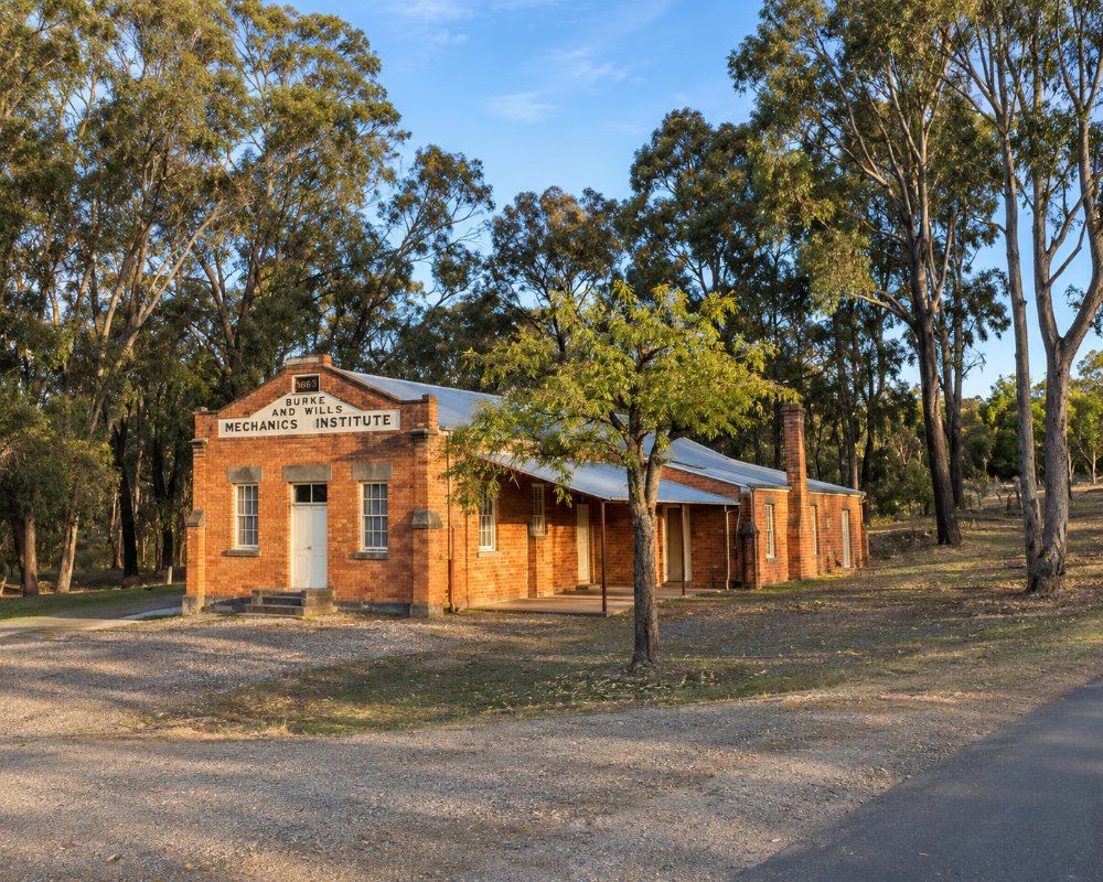
Fryerstown’s Burke and Wills Mechanics’ Institute hall of 1863, its old courthouse and its 1861 churches survive from the boom years. The ruins of the Duke of Cornwall engine house, built around 1865, are on the state and national heritage registers, and the Herons Reef diggings lie south-west of the village.
Castlemaine Diggings
Both villages are within the Castlemaine Diggings National Heritage Park, crossed by the Goldfields Track.
Sailors Gully and the Loddon Walks
From Vaughan Springs, the Goldfields Track runs south-east to Central Springs on an easy return walk rich in birdlife. The harder walk goes south-west, up and over the steep bank of the Loddon River to Sailors Gully and its old mines. Back at the springs, the deciduous trees planted along the entrance road turn gold in autumn, and the big slide is a favourite with children.
Prospecting and the Miner’s Right
The forests around both villages are among the best-known prospecting grounds in the Goldfields, and Chokem Flat is a popular base. A Miner’s Right, a ten-year permit issued by the Victorian Government, is needed for any panning or metal detecting, and Parks Victoria’s Castlemaine Prospecting Map shows where it is allowed in the national heritage park. It is not allowed at Vaughan Springs, at the campgrounds or on historic sites such as Herons Reef.
Where To Stay
There is no accommodation in either village. The Upper Terrace campground at Vaughan Springs is free, needs no booking and suits caravans, and Chokem Flat and Warburtons Bridge camping areas are nearby. Castlemaine has motels, B&Bs and caravan parks.
Campers have three free, unpowered bush campgrounds within a few kilometres, none needing a booking. Chokem Flat, on Fryers Creek off Campbells Creek–Fryers Road north of Fryerstown, is large and suits caravans and campervans. It has picnic tables and a central fireplace but no toilets, so bring a portable one. Warburtons Bridge, on a bend of the Loddon off Vaughan–Drummond Road south of Vaughan, has a toilet, tables and fireplaces. Dogs on a lead are fine at both. The Upper Terrace above Vaughan Springs uses the toilets in the day area below, but dogs are not allowed at Vaughan Springs.
There are no bins, firewood collection is banned, fires are allowed only in the fireplaces provided and never on Total Fire Ban days, and the park closes on Catastrophic Fire Danger days. The forest roads are mostly unsealed, so take them slowly with a van. The nearest dump point is on Bridge Street in Harcourt, about 25 km north, and Castlemaine, about 12 km away, has fuel, supermarkets and two caravan parks with powered sites and cabins.
Eat & Drink
There are no shops or cafes in Fryerstown or Vaughan, so bring a picnic. Castlemaine and Guildford are about 10 to 15 minutes away.
Neither village has a shop, so stock up in Castlemaine, about 12 km north, where Johnny Baker’s bakeries, the cafes of Barker and Mostyn streets and two supermarkets are within a few blocks. The nearest meals are at Guildford, about 6 km west of Vaughan, where the Stables behind the old general store serves wood-fired pizza with wine, beer and cocktails, and the post office sells barista coffee. At Campbells Creek, on the way to Castlemaine, the Five Flags Hotel serves meals every day and the Five Flags Merchants Cafe next door does coffee and breakfast. The Red Hill Hotel at Chewton, east of Fryerstown, opens for pub dinners from Thursday to Sunday. Vaughan Springs has a free electric barbecue and a picnic shelter. Fill up with fuel in Castlemaine.
History
This is Dja Dja Wurrung Country. Gold was found in Fryers Creek in late 1851, and the area quickly filled with diggers. The Fryerstown Antique Fair, held over the Australia Day weekend from the mid-1970s to raise money for the hall, ran for more than 40 years before ending around 2019.
Getting to Fryerstown and Vaughan
Fryerstown is about 115 km north-west of Melbourne, around an hour and a half’s drive via the Calder Freeway and Castlemaine. There is no public transport.
Experiences
- Historic/Heritage
- Rural/Country
- Self-Drive
Popular Activities
- Bush Walking
- Caravan and Camping
- Driving
- Gold prospecting
- Sightseeing
- Swimming
About Fryerstown and Vaughan
- Locality: Rural locality
- Fryerstown and Vaughan Postcode: 3451
- State: Victoria
- Region: Goldfields
- Latitude: -37.1412
- Longitude: 144.2499
- Elevation: 342m
- Timezone: Australia/Melbourne
