Rouse Hill, NSW
Rouse Hill is located approximately 43 kilometres (50 minutes drive) northwest of the Sydney CBD in the Shire of Baulkham Hills.
Known for:
- The Rouse Hill Town Centre, a large walkable shopping centre
- The historic Rouse Hill House and Farm, which is a heritage-listed former farm and now a museum.

History of the area
The Rouse Hill region, was originally home to the Darug people. As the primary custodians of the vast majority of the Greater Sydney area, the Darug were organised into various clans. Unfortunately, the rapid impact of European settlement led to their swift decline, leaving behind scant information about their use and interaction with the local area.
The name “Rouse Hill” traces back to the estate of Richard Rouse, a free settler who made his journey to the colony in 1801. In 1816, Rouse was granted a 450-acre plot of land at a location known as Vinegar Hill, northwest of Parramatta.
It was Governor Macquarie who proposed the estate be named Rouse Hill, a move historians speculate was intended to erase the convict history associated with the area following the Battle of Vinegar Hill.
This battle, which unfolded in 1804, was a conflict between escaped Irish convicts and government-civilian troops. In the aftermath of the skirmish, the area adopted the name Vinegar Hill, echoing a site in County Wexford, Ireland, where Irish and English forces had previously clashed in 1798.
Rouse Hill Today
Today, Rouse Hill stands as a testament to its rich and complex history, offering a unique blend of past and present.
Step into Rouse Hill, the gateway to the enchanting Hawkesbury Valley. At the heart of this vibrant suburb, you’ll find the Rouse Hill Town Centre, a bustling hub nestled at the intersection of Windsor Road and White Hart Drive. More than just a shopping centre, it’s a lively town square, brimming with outdoor dining options and a blend of indoor and outdoor spaces that invite exploration and discovery.
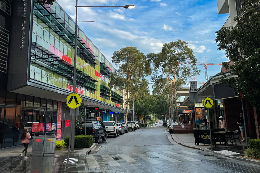
Since its grand opening in 2007, the Rouse Hill Town Centre has revolutionised retail and residential living in North Western Sydney, making it a convenient and accessible destination.
The Town Centre is a modern-day market town, merging traditional charm with contemporary fashion, homewares, dining, community services, and lifestyle choices. With over 230 specialty stores, including household names like Woolworths, Coles, Big W, Target, and a Reading Cinema, you’re sure to find everything you need in one convenient location.
The Rouse Hill Town Centre isn’t just a shopping destination; it’s a hub of learning and play. It houses the North West Community College & Learn 2, the Vinegar Hill Library, and interactive play areas for children, like The Backyard. Families can also find respite in The Secret Garden, a tranquil oasis amidst the hustle and bustle.

Recognised with several international planning & design awards, the Town Centre is a testament to sustainable shopping, entertainment, and community facilities. It’s a place where environmental responsibility and community spirit are woven into the fabric of its design.
Rouse Hill is an ever-evolving suburb, with new land and package deals continually emerging. “The New Rouse Hill” is a flourishing community in Sydney’s picturesque Hills District, set to welcome approximately 4500 residents upon completion.

Living in Rouse Hill means having everything you need at your fingertips. From lush parks and open spaces to the bustling Town Centre, top-notch schools, and well-established transport networks, it’s a place where convenience and lifestyle harmoniously intertwine.
Things To Do
Rouse Hill forms a border between rural and urban landscapes. Although part of a major residential development, Rouse Hill still retains many open farmlands. The area also boasts Rouse Hill Regional Park and historic Rouse Hill Estate, which dates back to 1813.
Rouse Hill Estate
Rouse Hill Estate stands as a beacon of Australia’s rich cultural heritage. Its significance extends beyond its artefacts, furnishings, buildings, and gardens. It is a living testament to the continuous family occupancy of a country house in New South Wales, making it one of the most historically important properties in the country.

The estate was founded by Richard and Elizabeth Rouse in 1813 and has since been home to six generations of the same family. This unique lineage has imbued the estate with an unparalleled historical depth, spanning over 185 years of Australian history.
As you wander through the sprawling 13 hectares of the estate, you’ll discover more than just a Georgian house. The stables, summerhouse, and various outbuildings each tell their own story, offering a glimpse into the past and a deeper understanding of Australia’s history.
From the carefully preserved artefacts to the meticulously maintained gardens, every corner of the Rouse Hill Estate is a piece of a larger historical puzzle. It’s an opportunity to step back in time and experience the evolution of Australian family life over nearly two centuries.
The estate welcomes visitors on the second Sunday of every month, offering a unique opportunity to explore this historical gem. Whether you’re a history enthusiast or simply curious about Australia’s past, a visit to Rouse Hill Estate is a journey through time you won’t want to miss.
Rouse Hill Regional Park
Nestled in the heart of Sydney’s north-west, Rouse Hill Regional Park is a verdant oasis that offers a refreshing escape from the hustle and bustle of city life. This expansive park is a beloved destination for locals and visitors alike, offering a diverse range of recreational activities and natural beauty.

The park is a haven for outdoor enthusiasts, with a multitude of walking and cycling trails that meander through its lush landscapes. These trails are perfect for a leisurely stroll or an invigorating bike ride, offering stunning views of the park’s diverse flora and fauna.
For families, the park is a treasure trove of fun and adventure. The park features a large playground that’s sure to delight children of all ages, complete with slides, swings, and climbing structures. There’s also a spacious picnic area, making it the perfect spot for a family outing or a leisurely lunch in the great outdoors.

But the park is more than just a recreational destination. It’s also a vital habitat for a variety of wildlife species. Birdwatchers will be delighted by the array of bird species that call the park home, while nature lovers will appreciate the park’s commitment to preserving its natural ecosystems.
The Regional Park also hosts a range of events throughout the year, from outdoor concerts to community festivals. These events bring the community together and add a vibrant touch to the park’s tranquil atmosphere.
House Down Under
The House Down Under in Rouse Hill is known as Australia’s first inverted house photo experience. The house offers a unique and interactive photography opportunity where visitors can explore various rooms and capture gravity-defying images that give the illusion of being upside down.

The House Down Under is designed with furniture, fixtures, and decor mounted on the ceiling, creating an upside-down effect. Visitors can take photos while standing on the ceiling, appearing as if they are defying gravity. It provides a fun and unconventional experience for photography enthusiasts, families, and tourists looking for unique attractions.
The upside-down house concept has gained popularity in various parts of the world, and the House Down Under in Rouse Hill brings this exciting experience to Australia. It offers a range of photo opportunities, allowing visitors to capture creative and memorable pictures.
It is located in Market Square, Rouse Hill Town Centre, between the centre and the Metro.
The Ettamogah Pub Experience
In the heart of Rouse Hill, you’ll find a unique pub that’s as much a part of the local character as the people who frequent it: The Ettamogah. This iconic establishment is more than just a place to enjoy a cold beer or a hearty meal; it’s a destination that embodies the spirit of Australian hospitality and camaraderie.
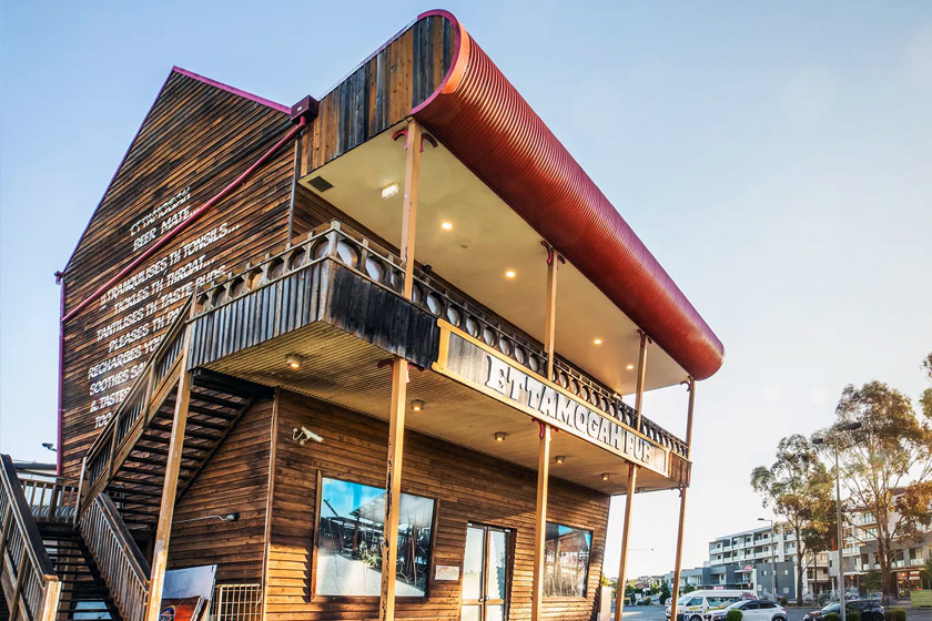
The Ettamogah, with its distinctive architectural design, is instantly recognisable. Its quirky, cartoon-like structure, inspired by the famous Ettamogah Pub featured in the Australian Post magazine, makes it a standout landmark in Rouse Hill.
Step inside, and you’ll be greeted by a warm, friendly atmosphere that’s as inviting as it is unique. The pub is renowned for its wide selection of beers and wines, as well as its menu of delicious, home-style meals. Whether you’re craving a classic Aussie burger, a succulent steak, or a refreshing salad, The Ettamogah has something to satisfy every palate.
But the appeal of The Ettamogah extends beyond its food and drink offerings. The pub is a hub of community activity, hosting a variety of events and live music performances throughout the year. It’s a place where locals and visitors alike can come together to enjoy good company, great entertainment, and a genuine Aussie pub experience.
For families, The Ettamogah offers a welcoming environment, complete with a dedicated kids’ play area. It’s a place where parents can relax and enjoy a meal while their children play in a safe and fun-filled setting.
Rouse Hill Cinema
Experience the exhilaration of the silver screen like never before at Reading Cinemas Rouse Hill! Prepare to be swept away by a state-of-the-art 9 screen cinema complex that boasts wall-to-wall screens, digital sound, and mind-blowing Dolby Digital 3D projection. With stadium seating and plush, comfortable seats, every moment of the cinematic adventure is pure bliss.
Immerse yourself in the captivating visuals of first-release movies in both 2D and Dolby Digital 3D, and don’t forget to take advantage of their value-packed candy bar deals. Located within the fantastic Rouse Hill Town Centre, Reading Cinemas Rouse Hill is the go-to destination for group outings and special events. Whether you’re planning a corporate function or a private gathering, they are designed to cater locally to your specific needs.
Parking is a breeze with ample availability every day. Guests can enjoy up to 4 hours of free parking by presenting their parking ticket at the box office. No need to stress about finding a spot.
Go on a 5km Park Run
Looking for a free and enjoyable way to kick-start your weekend? Look no further than Rouse Hill parkrun — a vibrant and welcoming community event that brings people together for a weekly 5km adventure. Whether you prefer to walk, jog, run, volunteer, or simply cheer on the participants, the choice is entirely yours!
Mark your calendars because the parkrun happens every Saturday at 8:00am. You can join it at the picturesque Rouse Hill Regional Park, nestled on Worcester Road in Rouse Hill, NSW 2155.
Best of all, there’s no fee to join in on the fun—it’s absolutely free! Just make sure to register before your first visit. Remember, you only need to register once with parkrun, and don’t forget to take a scannable copy of your barcode. Speed doesn’t matter — what matters is that you participate and enjoy yourself. So, regardless of your pace, join in for an unforgettable experience! Lace up your shoes, embrace the camaraderie, and make your Saturday mornings extraordinary at Rouse Hill parkrun.

Towns surrounding Rouse Hill include: Annangrove, Box Hill, Glenhaven, Kellyville and Nelson.
Nearest Airport: Sydney Kingsford Smith Airport, Mascot
Where to stay?
Popular Activities
- Mountain Biking
- Trail bike riding
- Bush Walking
- Golfing
- Horse Riding
- Shopping
- Food and Wine
About Rouse Hill
- Locality: Suburb
- Rouse Hill Postcode: 2155
- State: New South Wales
- Region: Sydney
- Latitude: -33.68207
- Longitude: 150.9154
- Elevation: 53m
- Population: 7965
- Median Income: $45812
- Area (Sq/km): 10.638
- Timezone: Australia/Sydney