
Mount York, NSW
Mount York is a narrow spur on the western rim of the Blue Mountains, five kilometres north-west of Mount Victoria at the end of a sealed road. On 28 May 1813 Gregory Blaxland, William Lawson and William Charles Wentworth reached this point and saw open grazing country below them, proof that the mountains could be crossed. It is now a reserve with lookouts, monuments and the start of several historic walks.
Known For
- The lookout of the 1813 crossing
- Four early roads down the mountain, now walking tracks
- Quiet picnic spots and rock climbing
Things To Do at Mount York
Lookouts and Monuments
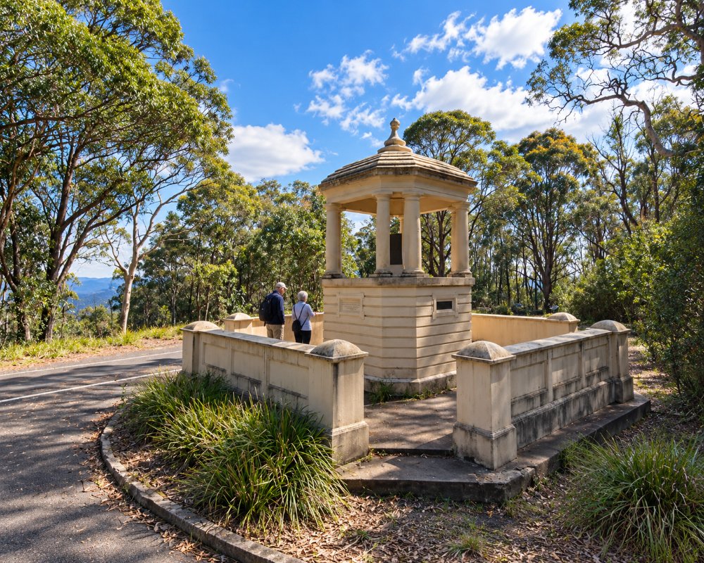
A stone obelisk and pavilion, put up from 1900 onwards, commemorate the three explorers, surveyor George Evans, and William Cox, who built the first road. Paths lead to fenced lookouts over the Hartley Valley. Bardens Lookout, on the road in, is another fine viewpoint.
Historic Road Walks
Coxs Road, built with convict labour in 1814 and 1815, went straight down the end of the spur, and its descent is so steep that carts were lowered with logs dragging behind as brakes. You can still walk it and see the pick marks in the rock. Lawsons Long Alley and Lockyers Road, cut in the 1820s as easier lines, are also walking tracks and can be joined into loops of three to five hours through Hartley Vale. Carry water and a map.
Rock Climbing
The cliffs on both sides of the spur have hundreds of bolted routes and are among the most used sport climbing crags in the mountains.
Hartley Historic Site
The village of Hartley, on the valley floor below Mount York, grew up on the road the explorers opened. National Parks runs it as a historic site with the old courthouse, the former St Bernard’s Church, a visitor centre open Thursday to Sunday, the Postmistress Cafe and Store and a boardwalk along the River Lett. While Victoria Pass is closed it is reached via Lithgow.
Mount Victoria Village
Five kilometres back, Mount Victoria has a museum in the old railway refreshment rooms, a heritage walk past the 1849 toll house, and Mount Vic Flicks, a cinema in the public hall, while Sunset Rock and Mount Piddington are good places to finish the day.
Where To Stay
A small, basic camping area near the end of the road has toilets and no other facilities, with a four-night limit; it was closed for a time after the 2019-20 bushfires, so check with the council before relying on it.
Mount Victoria, 5 km back, has the Victoria and Albert guesthouse on Station Street, along with cottages and bed and breakfasts. The nearest caravan park is Blackheath Tourist Park, about 12 km away, with powered slab sites for large vans, cabins and glamping tents, and Katoomba Tourist Park, about 22 km away, has powered sites and cabins. Bring water and a gas stove if you are camping, and buy firewood beforehand, as collecting it is banned.
Eat & Drink
There is nothing at Mount York. Bring a picnic, or eat at Mount Victoria.
The closest food is in Mount Victoria, where the Victoria and Albert guesthouse has a cafe for breakfast and lunch every day and a restaurant and bar for dinner on Friday and Saturday. Blackheath has Ates for wood-fired Mediterranean food, Blaq for seasonal dinners, the Victory Cafe in the old theatre and the Gardners Inn pub, plus a supermarket and fuel. On the valley floor, the Postmistress Cafe and Store at Hartley Historic Site serves coffee and light meals in the old post office, though while Victoria Pass is closed (until about mid-2027) the drive down is a long detour via Lithgow.
Mount Victoria’s single-screen cinema, Mount Vic Flicks, also sells home-made choc tops and treats at its sessions.
History
Mount York was the only way west for the first seventeen years of the road. Governor Macquarie came down it in 1815 on his way to found Bathurst. The grade defeated many travellers, and after several attempts at a better line Thomas Mitchell opened Victoria Pass in 1832, leaving the old roads to the bush.
Mount York lies in the country of the Darug people, close to the eastern edge of Wiradjuri country. Lawsons Long Alley and Lockyers Road, started in 1828 and never finished, were each attempts to find a gentler line down the escarpment, and the memorials on the summit were added over the following century, many to mark anniversaries of the 1813 crossing.
Getting to Mount York
From Mount Victoria, take Mount York Road from the Great Western Highway, just west of the village. The turn-off is on the Sydney side of the Victoria Pass closure, so access is not affected.
Mount York is about 130 km from Sydney, a little over two hours by the M4 Motorway and Great Western Highway. The road in is sealed but narrow, with limited parking at the end, so a caravan is better left in Mount Victoria or Blackheath, and the nearest station is Mount Victoria, about an hour’s walk along the road.
Experiences
- Active
- Historic/Heritage
- Mountain
- Nature based
Popular Activities
- Abseiling
- Bush Walking
- Caravan and Camping
- Rock Climbing
- Sightseeing
About Mount York
- Locality: Rural locality
- Mount York Postcode: 2786
- State: New South Wales
- Region: Blue Mountains
- Latitude: -33.5547
- Longitude: 150.2203
- Timezone: Australia/Sydney
