
Merriwagga, NSW
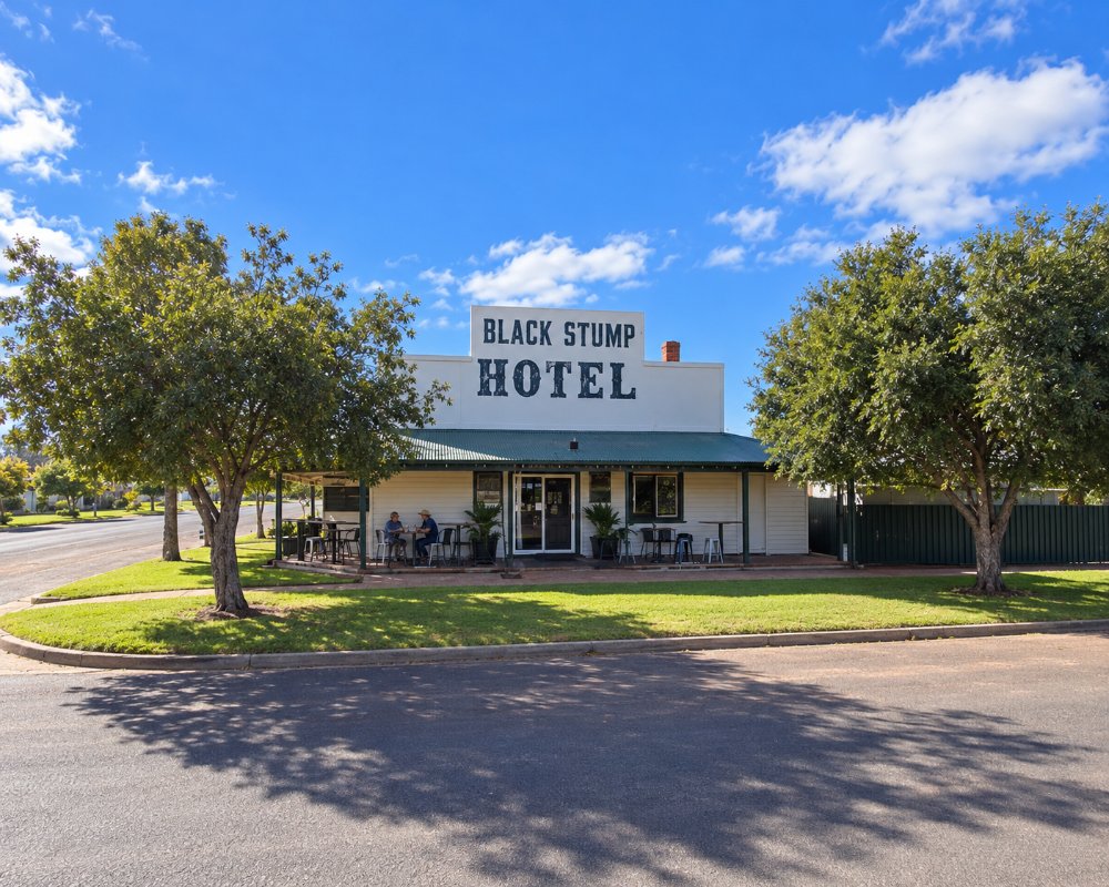
Merriwagga is a tiny village on the Kidman Way in the western Riverina, about 65 km north of Griffith and 40 km south of Hillston. Dominated by grain silos, it would be easy to drive straight past. But Merriwagga claims to be the origin of one of Australia’s best-known sayings, beyond the black stump, and its pub has a bar so high that drinkers need a stool to reach it.
Known For
- The Black Stump legend
- A pub with a very tall bar
- Wheat silos on the Kidman Way
A few dozen people live in Merriwagga. The country around it is flat red-soil plain, sown to wheat or covered in belah and mallee scrub.
Things To Do
The Black Stump
In 1886 a bullock driver, James Blain, and his wife Barbara camped at a waterhole near here. While he was away, her dress caught fire at the campfire and she was burnt to death. Blain is said to have told the inquest that when he found her she looked like a black stump. The waterhole became known as Black Stump Tank, and the name spread. A memorial marks the site on McKinley Road, reached by the unsealed, dry-weather Black Stump Trail, and Barbara Blain’s grave is in the cemetery at Gunbar, to the south. Other towns, including Coolah and Blackall, have their own black stump stories.
Black Stump Hotel
The village pub is known for a bar about 1.3 metres high, said to be the tallest in the Southern Hemisphere. One explanation is that it was built so that stockmen could ride up and be served without dismounting.
Pioneer Women’s Memorial
A memorial in the village honours the women who lived and worked in the district in its early years.
The Black Stump Trail
The self-guided Black Stump Trail starts from the signs in Merriwagga Park and runs through the surrounding farmland, past the memorial at the site of the 1886 tragedy, to Barbara Blain’s grave in the old Gunbar cemetery. Several sections are unsealed and suitable only in dry weather.
Goolgowi and Rankins Springs
Goolgowi, about 20 km south-east at the crossroads of the Kidman Way and the Mid Western Highway, has fuel and a pub, and Rankins Springs, further east, is known for its bird hides and a junk art gallery.
History
Merriwagga is in the country of the Wiradjuri people.
The village grew around a railway siding on the line from Griffith to Hillston, which opened in 1923, and its name is said to come from nearby properties. It has served the surrounding wheat and sheep farms ever since.
The village was gazetted in 1924, and farm blocks were opened in 1925 for wheat growing in the mallee; many settlers walked off their blocks in the Depression.
Where To Stay
The Black Stump Hotel has seven rooms, and the Old School Caravan Park in Marne Street has powered sites and cabins.
The Old School Caravan Park, in the former school grounds, has nine powered sites, two cabins, two on-site vans, an amenities block and a barbecue area. Book ahead with both, as they are small, owner-run places.
Griffith and Hillston have motels and caravan parks.
Goolgowi, 20 km south-east, has a pet-friendly council caravan park with powered drive-through sites and a dump point, and two motels.
Eat & Drink
The Black Stump Hotel serves dinner on Friday and Saturday nights; ring ahead on other days.
The bar is worth seeing even if you only stop for a cold drink. The village has no shop or fuel, so arrive stocked up; Goolgowi has a service station, a hotel and an Ex-Servicemen’s club, and Hillston has a supermarket and cafes.
Getting There
Merriwagga is on the Kidman Way, about 70 km, or 50 minutes, north-west of Griffith.
Hillston is about 42 km north, and the Kidman Way is sealed, flat and suits caravans.
Experiences
- Historic/Heritage
- Remote
- Rural/Country
- Self-Drive
Popular Activities
- Caravan and Camping
- Driving
- Outback
- Sightseeing
About Merriwagga
- Locality: Rural locality
- Merriwagga Postcode: 2652
- State: New South Wales
- Region: Country NSW
- Latitude: -33.82029
- Longitude: 145.62235
- Elevation: 113m
- Timezone: Australia/Sydney
