
Dover Heights, NSW
Dover Heights is a small residential suburb on the ocean cliffs of the eastern suburbs, about nine kilometres from the centre of Sydney, between North Bondi and Vaucluse. It sits on a high ridge with the Pacific on one side and the harbour on the other, and it has some of the widest views in the city.
Known For
- Dudley Page Reserve and its city panorama
- Clifftop walks above the ocean
- A quiet link between Bondi and Watsons Bay
The suburb is almost entirely houses, many of them large and modern, built to take in the views. Military Road and Old South Head Road run along the ridge. On the eastern side, a strip of parkland follows the cliff edge.
Things To Do in Dover Heights
Dudley Page Reserve
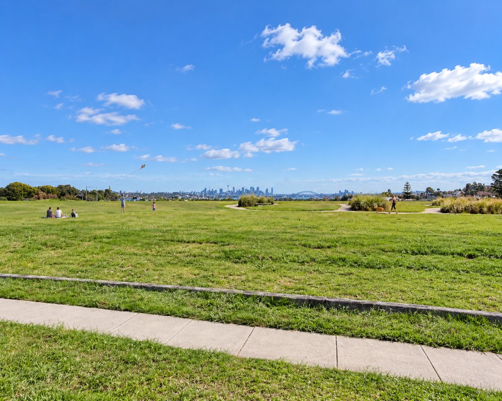
This open, grassy reserve sits at one of the highest points in the eastern suburbs. The view west takes in the whole harbour, the bridge, the Opera House and the city skyline, and it is a famous place to watch the sunset and the New Year’s Eve fireworks.
Clifftop Walk
A path follows the edge of the sandstone cliffs through a chain of reserves, with the ocean far below. Heading north it continues through Vaucluse to the Macquarie Lighthouse and on to The Gap at Watsons Bay, about four kilometres away. To the south it leads towards North Bondi. In winter and spring it is a good vantage point for spotting migrating whales.
Rodney Reserve
On the cliff edge, this reserve was the site of a pioneering radio astronomy station in the late 1940s, where scientists made some of the first discoveries of radio sources beyond the solar system. A replica antenna and a plaque mark the spot.
After the war, the old RAAF radar station on the cliff became a field station of the CSIRO Division of Radiophysics, where John Bolton’s team identified Taurus A, later matched to the Crab Nebula. The replica of their 1951 antenna went up on the original mount in 2003.
The Bondi to Watsons Bay Walk
The clifftop reserves form part of the walk from Bondi to Watsons Bay, about 6 km one way. Head south to North Bondi and the Ben Buckler headland, or north past Diamond Bay and Macquarie Lighthouse to The Gap. Bus 380 links both ends.
Where To Stay
There is no visitor accommodation in Dover Heights.
Bondi Beach, five minutes south, has hotels, apartments and hostels.
Hotel Ravesis on Campbell Parade is a small boutique hotel facing Bondi Beach, the Watsons Bay Hotel, about 4 km north, has 31 rooms, and Bondi Junction has apartment hotels next to the station. Caravans have nowhere to stay in the eastern suburbs; the nearest tourist parks are Discovery Parks – Lane Cove and BIG4 Sydney Lakeside at North Narrabeen.
Eat & Drink
The suburb has only a few local shops. Rose Bay, at the foot of the hill, and Bondi both have a wide choice of cafes and restaurants.
At North Bondi, North Bondi Fish serves seafood and cocktails over the beach and the North Bondi RSL has a deck looking down the length of Bondi Beach, and Icebergs Dining Room and Bar sits above the famous ocean pool. Catalina at Rose Bay and Doyles at Watsons Bay are short drives away. The nearest supermarkets are at Bondi Beach, Rose Bay and Bondi Junction.
Up the hill, The Grumpy Baker on Old South Head Road in Vaucluse and Bake Bar in Rose Bay are the closest bakery cafes.
History
Dover Heights is on the land of the Bidjigal, Birrabirragal and Gadigal people. It was named for the supposed resemblance of its cliffs to those of Dover in England. The exposed ridge was used for market gardens and defence posts before being built over with houses from the 1920s.
The name first appears in council records in 1886. During the Second World War the RAAF ran a coastal radar station on the clifftop at what is now Rodney Reserve, and CSIRO used the site for radio astronomy from 1946 to 1954.
Getting to Dover Heights
Buses run from Bondi Junction station along Military Road and Old South Head Road. By car it is about 20 minutes from the city centre.
Bus 380 runs from Bondi Junction through Bondi Beach and Dover Heights to Watsons Bay.
Experiences
- City
- Historic/Heritage
- Nature based
- Relaxation
Popular Activities
- Bush Walking
- Sightseeing
About Dover Heights
- Locality: Suburb
- Dover Heights Postcode: 2030
- State: New South Wales
- Region: Sydney
- Latitude: -33.8744
- Longitude: 151.2804
- Elevation: 80m
- Timezone: Australia/Sydney
