
Warracknabeal, VIC
Warracknabeal is the main town of the northern Wimmera, a wheat and sheep centre of about 2,400 people on Yarriambiack Creek, about 330 km north-west of Melbourne and 58 km north of Horsham. Its wide main street, Scott Street, is lined with old banks, hotels and shops from the boom years of the late 1800s and early 1900s, and grain silos rise above the town on every side.
It is a handy base for the northern half of the Wimmera Silo Art Trail, with the painted silos at Brim and Sheep Hills within half an hour and Rosebery about 45 minutes north, and a comfortable stop for caravanners travelling the Henty Highway towards the Mallee.
Known For
- Wheatlands Agricultural Machinery Museum
- Heritage buildings on Scott Street
- Gateway to the northern Silo Art Trail
Things To Do in Warracknabeal
Wheatlands Agricultural Machinery Museum
On the Henty Highway at the edge of town, the Wheatlands Agricultural Machinery Museum displays a huge collection of tractors, harvesters, ploughs and farm machinery that tells the story of wheat growing in the Wimmera. It opens Friday to Monday, with a break at lunchtime.
Heritage Walk
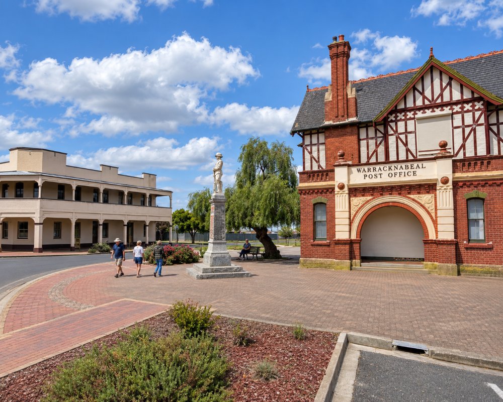
Warracknabeal has some fine old buildings. The Historical Centre, in the former State Savings Bank of 1909 on Scott Street, opens for a couple of hours each afternoon. Look for the Tudor-style post office of 1907, the water tower of 1886 and the log lock-up of 1872 on Devereux Street, one of the oldest buildings in the district.
Yarriambiack Creek
Walking paths follow Yarriambiack Creek through town, past the weir pool and parkland, a pleasant spot for an evening stroll or a picnic in the shade of the river red gums.
Y-Fest at Easter
Easter is the town’s big weekend, when Y-Fest brings a street parade, the Warracknabeal Cup race meeting, golf, an art show and the Vintage Machinery Rally. The next rally is on 27 and 28 March 2027. Book accommodation well ahead.
The Silo Art Trail
The Wimmera Silo Art Trail begins just north of town at Brim, where Guido van Helten painted Victoria’s first silo artwork in 2015 and 2016. South-east of town the Sheep Hills silos are also painted, and the trail runs north through Brim and Rosebery to Lascelles and Patchewollock.
Warracknabeal Courthouse
The old courthouse at 30 Woolcock Street sat as a court of petty sessions until 1989. Working Heritage, the shire and Monash University’s art and design faculty have turned it into an arts hub and heritage stay, which was launched in November 2025, so look out for exhibitions and residencies as well as the building itself.
Tourist Information Centre
The visitor centre at 119 Scott Street has been run by volunteers from the Warracknabeal Action Group since 2025 and opens seven days. Call in for Silo Art Trail maps, heritage walk notes and local produce and crafts.
Where To Stay
The Warrack Motel on Lyle Street and the Werrigar Motel at the Shell roadhouse on the Henty Highway both have rooms, and the old Warracknabeal Courthouse has been turned into a heritage stay.
Warracknabeal Caravan Park, on Lyle Street beside the creek, has powered and unpowered sites, cabins and a dump point, and is an easy walk from Scott Street. The Henty Highway is sealed and suits caravans, and Warracknabeal is the best place to refuel and restock before heading north into the Mallee, where towns are small and far apart.
The Warrack Motel at 2 Lyle Street sits on the bank of Yarriambiack Creek, about 500 m from Scott Street; you can fish from about 20 m outside your door, there is a camp kitchen for guests, and it caters for work crews as well as travellers. The Warracknabeal Courthouse at 30 Woolcock Street opened as a two-bedroom, two-bathroom heritage stay for up to four people in late 2025.
The caravan park on Lyle Street added three council cabins in 2023, and its dump point is free. It has barbecues, a creekside walking track and online bookings. Within half an hour north, Brim’s Redda’s Park on the Brim Weir Pool foreshore has powered and unpowered sites and a swimming area, about 25 km away; Beulah’s Creekview Caravan Park is about 45 km north. To the south, the Minyip Caravan Park sits in the Minyip Wetlands and Murtoa’s caravan park and community cabins are on Lake Marma, about 45 km away.
Fuel is on Scott Street and at the Werrigar Roadhouse on the Henty Highway.
Eat & Drink
Taylor’s Palace Hotel on Scott Street serves classic pub meals, and The Local 165 Cafe and Bar, further along Scott Street, does breakfast and lunch, with pizza on weekends. Warrack Hot Bread is the town bakery for pies and fresh bread. The Creekside Hotel at 4 Scott Street is trading again after closing at the start of 2025, and its parma shared Parma of the Year at the 2026 AHA (Vic) awards.
Scott Street holds almost all of the town’s eating. Taylor’s Palace Hotel at 99 Scott Street reopened in 2019 after seven years closed and is a family-friendly pub serving classic counter meals. The Creekside Hotel at the creek end of Scott Street is the other pub, and its parma shared the state’s Parma of the Year title at the 2026 AHA (Vic) awards. The Local 165 Cafe and Bar at 165-167 Scott Street is a licensed cafe for breakfast and lunch every day, and it stays open into the evening on Fridays and weekends for pizza. At Easter, the Lions Club community market is part of the town’s festival weekend.
Worth the drive: in Murtoa, about 45 km south, the Lazy Lizard Cafe on Marma Street is known for its coffee and homemade food, and in Rupanyup, about 50 km south, the Nimmo Kennedy Bazaar on Cromie Street is a coffee shop full of teapots, plants and antiques.
Warracknabeal has a supermarket on Scott Street, and fuel on Scott Street and the Henty Highway; it is the best place to restock before the Mallee.
History
This is Wotjobaluk Country. Major Thomas Mitchell crossed the plains in 1836, and in 1845 the Scott brothers took up a run here and named it Werracknabeal, said to refer to the gums along the creek. The run was broken up and the land sold in 1887, the railway had arrived the year before, and the town grew as a busy wheat centre.
Getting to Warracknabeal
Warracknabeal is about 330 km north-west of Melbourne, about four hours via Ballarat, Ararat and Stawell, or via Horsham, 58 km south on the Henty Highway. V/Line trains run from Melbourne to Ararat, where coaches continue north through Warracknabeal towards Hopetoun and Ouyen.
Experiences
- Historic/Heritage
- Rural/Country
- Self-Drive
Popular Activities
- Bird Watching
- Caravan and Camping
- Driving
- Fishing
- Shopping
- Sightseeing
