
Cooyar, QLD
Cooyar is a town of about 250 people on the New England Highway, roughly 95 kilometres north of Toowoomba and 20 kilometres south of Yarraman. It nestles in a valley where Cooyar Creek cuts through timbered hills, and its old pub and creekside park have made it a regular stop for travellers heading to the South Burnett and the Bunya Mountains.
Known For
- Swinging Bridge Park and its camping area
- The Palms National Park, a pocket of piccabeen palms
- The Muntapa Tunnel and its bats
Things To Do in Cooyar
Swinging Bridge Park
A suspension footbridge crosses Cooyar Creek to a shady reserve where travellers can camp for a small donation. It is a short walk from the hotel and shops.
The Palms National Park
Eight kilometres north-east of town, this tiny park protects a spring-fed gully filled with piccabeen palms, strangler figs and bunya pines. A circuit walk of less than a kilometre loops through it on a boardwalk, and flying foxes often roost overhead.
Muntapa Tunnel
South-west of Cooyar, a disused railway tunnel almost 300 metres long passes beneath the Great Dividing Range. It shelters a seasonal colony of bent-wing bats, and fences part way in from each entrance keep walkers away from the roost. A picnic area and short track lead to the entrance.
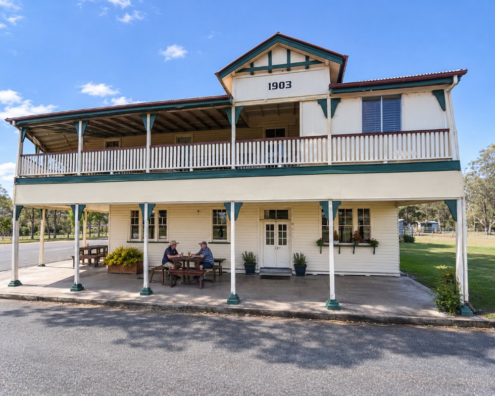
The hotel
The two-storey timber pub in the main street is a fine example of a country hotel and serves meals.
Cooyar Show and rodeo
Each February the Cooyar Agricultural Show fills the showground with classic country competitions, and its night rodeo is the crowd favourite. The showground also hosts endurance rides through the year.
Platypus in Cooyar Creek
The swinging bridge was rebuilt in 1988 after floods swept the earlier one away. Walk quietly along the creek bank below it at dawn or dusk, when platypus are sometimes seen in the pools.
Where To Stay
Camp at Swinging Bridge Park or stay at the hotel.
Toowoomba Regional Council allows camping in Swinging Bridge Park for up to 48 hours in any 14 days, on the bank above Cooyar Creek, with shelters, picnic tables, a barbecue, a playground, power and bins; pets must be on a lead, and the nearest toilets are in Memorial Park on McDougall Street. Groups and event campers can ask the Cooyar Agricultural Society about the showground. Yarraman Caravan Park and Cabins, about 20 kilometres north, has powered, unpowered and private ensuite sites on 12 by 12 metre pads, pet-friendly cabins, a pool, a camp kitchen and a dump point, and it won a 2026 guest-voted award from the state caravan parks association.
Crows Nest Tourist Park lies to the south on the same highway. The Palms National Park has no camping. Large rigs should not tow up to the Bunya Mountains from here; leave the van in Cooyar or Yarraman and drive up through Maidenwell.
Eat & Drink
The hotel and a cafe serve meals, and there is a general store.
Cooyar’s general store on the highway covers basics and cold drinks for a picnic in Swinging Bridge Park. For a wider choice, Yarraman, about 20 kilometres north, has the Royal Hotel on Toomey Street, a family country pub open daily from late morning with pub meals, beers on tap and a bottle shop, plus a bakery and cafes. Maidenwell, on the way to the Bunya Mountains, has a country pub and the Maidenwell Trading Post, which serves lunch and coffee and sells locally grown Yalbury olive products. Fill up with fuel in Yarraman or Maidenwell before the climb, as there is none on the mountain.
History
Cooyar began as a timber town, milling hoop pine and hardwood from the surrounding forests. A branch railway from Oakey operated from 1913 to 1964.
Getting to Cooyar
Cooyar is on the New England Highway, about an hour and ten minutes north of Toowoomba through Crows Nest.
Experiences
- Caravan and Camping
- Environmental
- Farm/Station
- Historic/Heritage
- Nature based
- Rural/Country
- Self-Drive
Popular Activities
- Bird Watching
- Bush Walking
- Caravan and Camping
- Driving
- Fishing - Estuary
- National Park
- Off Road Driving
- Rainforest
- Sightseeing
- Wildlife
About Cooyar
- Locality: Rural locality
- Cooyar Postcode: 4402
- State: Queensland
- Region: Southern Queensland Country
- Latitude: -26.98309
- Longitude: 151.83234
- Elevation: 434m
- Population: 224
- Median Income: $20072
- Area (Sq/km): 94.589
- Timezone: Australia/Brisbane
