
The Hummock, QLD
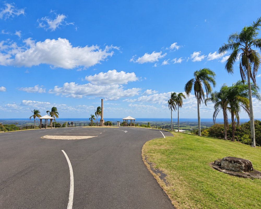
The Hummock is a low, rounded hill rising from the cane fields halfway between Bundaberg and Bargara. At 96 metres it is hardly a mountain, but it is the only high ground for many kilometres in any direction, and the lookout on its summit gives the best view in the district. It is also the reason the landscape looks the way it does: The Hummock is an extinct volcano, and its lava made both the rich red soil of the farms and the black rocky shore of the coast.
Known For
- A 360-degree view over cane fields, city and coast
- An extinct volcano that shaped the Bundaberg landscape
- Dry-stone walls built by South Sea Islanders
The volcano last erupted around a million years ago, sending basalt flows east to the sea and west towards the river. Over time the rock weathered into deep, fertile soil. When sugar planters cleared the land in the 1870s and 1880s, they found it strewn with volcanic stone, which their South Sea Islander labourers stacked into long walls along the paddock boundaries.
Things To Do at The Hummock
The lookout
A sealed road winds to a small park on the summit, with a viewing platform, picnic tables and information signs. To the east, the view runs across a patchwork of red soil and green cane to the coast from Burnett Heads to Elliott Heads, with the sea beyond. To the west lie Bundaberg, the chimney of the sugar mill and rum distillery, and the ranges on the horizon. It is best early in the morning or late in the afternoon, and during the crushing season, from about June to November, you may see cane fires glowing at dusk.
Hinkler memorial
A memorial at the lookout honours Bert Hinkler, the Bundaberg-born aviator who made the first solo flight from England to Australia in 1928. A memorial to him on the summit was unveiled in 1937, four years after his death.
The rock walls
On the roads around the base of the hill, especially towards Bargara and Mon Repos, look for the dry-stone walls that run for kilometres beside the cane. They are among the most visible reminders of the thousands of Pacific Islanders who were brought to Queensland, many against their will, to work the plantations. A section near Mon Repos is heritage listed.
Farm gates
The red soil around The Hummock grows much more than cane. Roadside stalls nearby sell sweet potatoes, tomatoes, zucchini, strawberries, macadamias and passionfruit in season, and the Bundaberg Barrel, home of the famous ginger beer, is a few minutes away on Bargara Road.
Sir Anthony’s Rest
Near the summit, a long, flat-topped mound of stacked volcanic stone, about 4 to 5 metres high, was built in 1888 as a resting place and lookout for Governor Sir Anthony Musgrave’s tour of the district. Hummock plantation owner William Farquhar had it built by South Sea Islander labourers, and it is now on the Queensland Heritage Register as a rare surviving governor’s tour shelter. It stands on farmland in Sir Anthony’s Rest Street, so view it from the road.
Woongarra Scrub boardwalk
Below the lookout, Maureen Schmidt Park has short walking tracks and a timber boardwalk through a remnant of the Woongarra Scrub, the dense vine forest that covered the volcanic soil before it was cleared for cane. It is an easy walk for families, and the shade makes a good contrast to the open summit. The parks are reached from Bargara Road or F.E. Walker Street, and the lookout is on Turners Way.
Where To Stay
There is no accommodation on The Hummock itself, though a few bed and breakfasts and holiday houses on its slopes enjoy the view.
Bargara’s beachfront apartments are five minutes east, and Bundaberg’s motels ten minutes west.
The summit park was set up by the Bundaberg branch of the RACQ, which bought the land in 1930 and opened it to motoring tourists in October 1931, and it is still a day-only stop with no camping. Most visitors stay at the coast or in the city, both within about 10 km. At Bargara, Kellys Beach Resort has self-contained villas in five and a half acres of tropical gardens with a pool and tennis court, a block from the beach. Turtle Sands at Mon Repos, about 8 km north-east, has camping, glamping and villas behind the turtle-nesting dunes, handy for the ranger-led turtle encounters from November to March.
Caravanners have the council parks at Elliott Heads (no pets) and Moore Park Beach (pets welcome), or Splitters Farm at Sharon, about 20 km west, with powered sites, safari tents and restored retro caravans on a working farm. Self-contained rigs can use the low-cost CMCA RV Park in central Bundaberg, which has a dump point and fresh water. The lookout road is narrow and the car park small, so leave a caravan at the bottom or visit without it.
Eat & Drink
Bring a picnic for the lookout, where there are tables but no kiosk. Cafes and restaurants are close by in Bargara, and the Windmill Cafe on See Street, a block from the beach, is a local favourite.
There is no kiosk or water at the lookout, so bring a picnic and drinks. The nearest food is a few minutes’ drive away: the Bundaberg Barrel on Bargara Road, about 4 km west, pairs ginger beer tastings with a gallery tour, and in Bargara, about 6 km east, The Windmill Cafe on See Street is known for coffee and bright, healthy breakfasts. Its sister Garden Mill Cafe is also in Bargara, and Bundaberg’s CBD is about 10 km west.
History
The hill is a significant place for the Taribelang Bunda people. Matthew Flinders took a bearing on it from the sloop Norfolk in 1799 and called it the Sloping Hummock, the first European name given to any feature of the district, and it served as a landmark for ships for the next century. The surrounding land became the Woongarra cane-growing district, one of the first and most productive in the region.
Getting to The Hummock
From Bundaberg, follow Bargara Road east for about ten kilometres and turn right at the sign for the lookout. From Bargara it is five kilometres west. The road to the top is narrow but sealed, with a small car park.
Experiences
- City
- Historic/Heritage
- Nature based
- Self-Drive
Popular Activities
- Bush Walking
- Driving
- Sightseeing
About The Hummock
- The Hummock Postcode: 4670
- State: Queensland
- Region: Bundaberg
- Latitude: -24.8440
- Longitude: 152.4290
- Timezone: Australia/Brisbane
