
Seventy-Five Mile Beach, Eli Creek and the Maheno Wreck, QLD
Seventy-Five Mile Beach runs almost the full length of the east coast of K’gari (Fraser Island), a broad, firm ribbon of sand between the surf and the dunes. It is the island’s main road, with speed limits and road rules, and also its airstrip, where small planes land between the four-wheel drives. Strung along it are three of the island’s best-known sights: the clear freshwater stream of Eli Creek, the rusting wreck of the Maheno and the coloured sand cliffs of The Pinnacles.
Known For
- Driving a beach that is also a highway and a runway
- Floating down the clear, cool water of Eli Creek
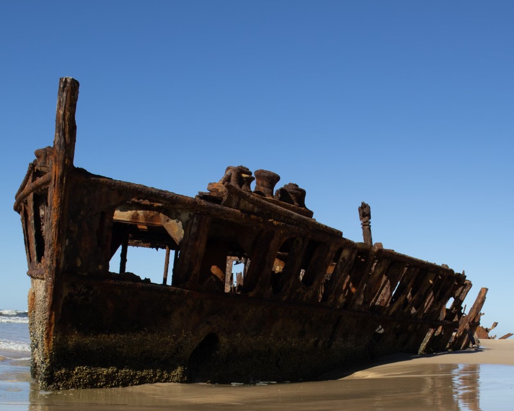
- The wreck of the SS Maheno, ashore since 1935
The beach stretches for about 120 kilometres from Hook Point in the south to Indian Head in the north. On one side is the open Pacific, on the other a wall of dunes broken by creeks, coloured cliffs and the occasional settlement, including Eurong and Happy Valley. Dingoes trot along the tide line, sea eagles sit on the dunes and, from July to October, whales pass offshore.
Things To Do on Seventy-Five Mile Beach
Drive the beach
Driving here is the heart of a K’gari trip, but it needs care. Travel only within about two hours either side of low tide, when the sand is hard and wide. Watch for washouts where creeks cross the beach, for pedestrians and anglers, and for aircraft landing in the marked zone. Speed limits apply and are lower near camps and settlements. A four-wheel drive with reduced tyre pressure and a vehicle permit are required.
Eli Creek
Eli Creek is the largest freshwater stream on the east coast, pouring about four million litres of clear water onto the beach every hour. A boardwalk follows it inland through pandanus and banksia; walk to the top, step in and float or wade back down with the current over a white sandy bed. The water is cool, shallow and safe for children, and many people bring an inflatable ring. It is busiest in the middle of the day.
The Maheno wreck
A few kilometres north of Eli Creek lies what is left of the SS Maheno, a trans-Tasman liner built in 1905 that served as a hospital ship in the First World War. In July 1935, while being towed to Japan for scrap, she was caught in a cyclone and driven ashore. Much of the hull has rusted away or sunk into the sand, but the remaining decks make a striking sight at sunrise. Stay off the wreck, which is unstable and sharp.
The Pinnacles and Red Canyon
North of the Maheno, The Pinnacles are a cluster of sand spires and cliffs coloured in bands of red, orange, yellow and cream by iron-rich minerals, best seen in early morning light. They are a sacred place for Butchulla women. Further along, Red Canyon and the Cathedrals show more coloured sand.
Scenic flights
Light aircraft take off from the beach for 15-minute flights over the island’s lakes, sandblows and rainforest, a memorable way to grasp its size. Flights are booked on the spot or through tour operators.
A warning about the surf
Do not swim in the ocean here. Strong rips, deep gutters and sharks make it dangerous, and there are no patrols. Swim in the creeks, the lakes or the Champagne Pools instead.
Beach driving conditions in 2026
QPWS sets the maximum speed on the beach at 80 km/h, and lower limits apply near camps and settlements. North of Yidney Rocks, drivers use the bypass track, or the beach when conditions allow. The Happy Valley beach access ramp is being rebuilt. It is fully closed from early October to early December 2026, with traffic sent round by the Happy Valley Back Track. From November to May, marine turtles nest on the beach, so drive slowly and keep off the dunes.
Rules at the Maheno
The wreck is now so fragile that QPWS bans going on it or within 3 metres of any part of it, and penalties apply. In its early years ashore, people held weddings and concerts on its decks. Photographs are best taken from the sand, ideally in early morning light.
The Cathedrals and Red Canyon
The Cathedrals are coloured sand cliffs in pinks, reds, yellows and orange. They run along about 18 km of Cathedral Beach, and the best of them face the beach between the Dundubara camping area and Wyuna Creek. Red Canyon, about 3 km north of Dundubara, has deeper red and brown tones. Climbing on the cliffs or collecting their sand is illegal, and digging into them is dangerous because they can collapse.
Where To Stay
National park camping zones lie behind the dunes along much of the beach, with fenced camping areas at Dundubara and elsewhere that are recommended for families because they keep dingoes out. All must be booked ahead.
Eurong has a resort and holiday houses, and Happy Valley, close to Eli Creek, has a retreat with cabins and private houses to rent.
For families, QPWS recommends its dingo-fenced camping areas. Along the beach these are Dundubara, about 75 km north of the Hook Point barge landing, with flushing toilets, coin-operated hot showers, water taps (treat the water before drinking), gas barbecues and fire rings, and sites for off-road camper trailers. There are also four smaller fenced beach camps with no facilities, where you must bring a portable toilet: Eli, just north of Happy Valley and a short drive from Eli Creek; One Tree Rocks; Cornwells, about 6 km from Eurong; and Wongai, just south of Eurong. Unfenced beach camping zones run behind the dunes for most of the beach.
Every QPWS site needs a camping permit, booked before you arrive. Cathedrals on Fraser is a privately run campground, also dingo-fenced, behind the dunes about 6 km north of the Maheno. It has powered and unpowered sites, permanent canvas tents, self-contained cabins and newer wilderness villas, plus a camp kitchen and laundry. Eurong’s resort, K’gari Beach Resort, is at the southern end of the main stretch. Off-road camper trailers suit the island. Ordinary caravans do not, and only off-road vans should attempt the crossing.
Eat & Drink
Shops, fuel and meals are available at Eurong and Happy Valley, at higher prices than on the mainland. Cathedrals on Fraser, about 6 km north of the Maheno, also has a store, cafe and fuel; elsewhere along the beach there is nothing, so carry food and plenty of drinking water. Creek water should be treated before drinking.
K’gari Beach Resort at Eurong has McKenzie’s on 75 Restaurant and Bar (buffet breakfast, lunch and dinner), Sid’s Bar, the Eurong Bakery and a general store, about 30 km south of Eli Creek. Cathedrals on Fraser, about 6 km north of the Maheno, has a large general store and a cafe serving breakfast, lunch, hot food and coffee, along with fuel. Happy Valley, about 10 km south of Eli Creek, has a store and bar. There is no food at Eli Creek, the Maheno or the Pinnacles, and QPWS asks visitors not to picnic at Eli Creek because dingoes frequent it.
History
The beach has been a travel route for the Butchulla people for thousands of years. From the 1860s timber-getters used it to move between camps, and from the 1960s sand miners worked the dunes at its southern end until mining was stopped in 1976. The Maheno’s stranding drew sightseers at once, and during the Second World War the wreck was used for bombing practice, which hastened its decay.
Getting to Seventy-Five Mile Beach
From Inskip Point, near Rainbow Beach, a barge crosses in ten minutes to Hook Point at the beach’s southern end. From River Heads, near Hervey Bay, barges run to the western side of the island, from where inland tracks cross to the beach at Eurong in about an hour. Day and overnight tours cover the beach for those without their own vehicle.
Experiences
- Historic/Heritage
- Island
- Nature based
- Soft Adventure
Popular Activities
- Beach
- Caravan and Camping
- Fishing - Beach
- Off Road Driving
- Scenic Flight
- Sightseeing
- Swimming
About Seventy-Five Mile Beach, Eli Creek and the Maheno Wreck
- Locality: Beach
- Seventy-Five Mile Beach, Eli Creek and the Maheno Wreck Postcode: 4581
- State: Queensland
- Region: Fraser Coast
- Latitude: -25.3050
- Longitude: 153.2180
- Timezone: Australia/Brisbane
