
Rushworth, VIC
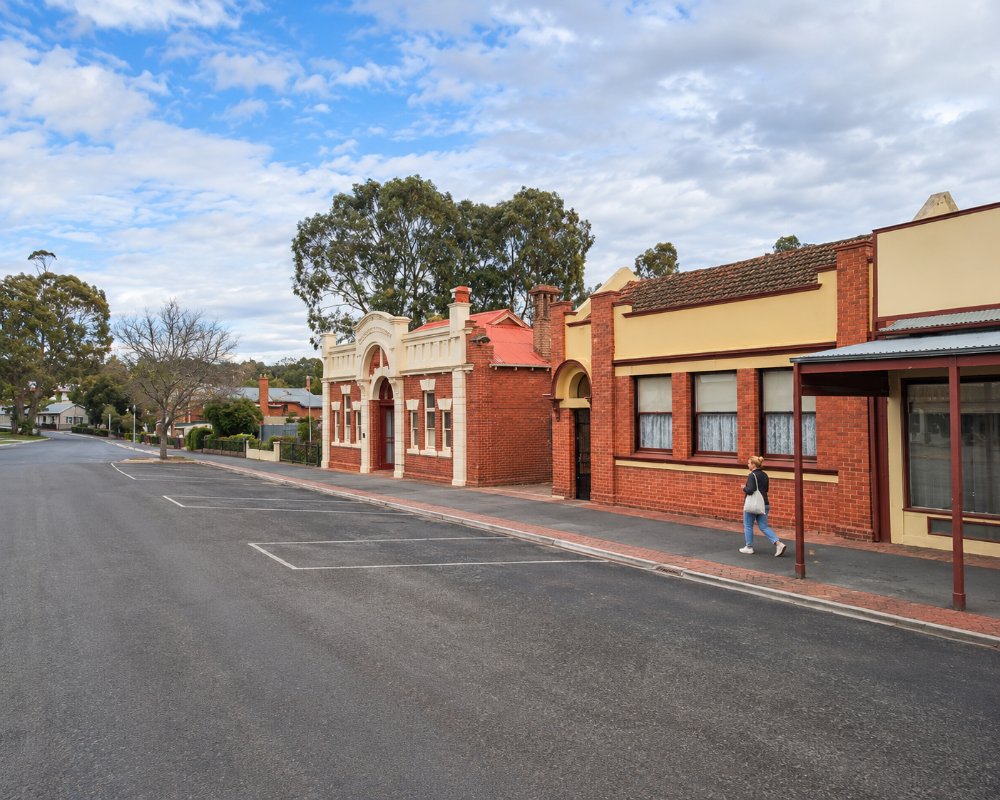
Rushworth lies on the edge of a large box-ironbark forest, about 165 km north of Melbourne and 20 km west of Murchison. Born in a gold rush in 1853, it has a classified heritage High Street of old shops and pubs, and the forest around it is dotted with old diggings, including the ghost town of Whroo.
Waranga Basin, just east of town, is one of the largest reservoirs in the region, popular for boating, fishing and water-skiing.
Known For
- Whroo Historic Reserve
- Waranga Basin
- A heritage gold-rush High Street
Things To Do in Rushworth
High Street
Rushworth’s High Street is lined with gold-rush buildings, including the Criterion Hotel of 1859, and the local museum is in the Mechanics’ Institute.
Whroo Historic Reserve
Whroo Historic Reserve, about 7 km south, covers about 500 hectares of forest around the site of a gold town that had about 2,100 people in 1857. The Balaclava Hill open cut, 25 metres deep, is on the Victorian Heritage Register, and the reserve also has an Aboriginal waterhole and an old cemetery.
Rushworth State Forest
The Rushworth State Forest is one of the largest box-ironbark forests in Victoria, good for walking, birdwatching and spring wildflowers.
Waranga Basin
Waranga Basin, begun in 1905, is held back by a 7 km earthen wall and was one of the largest reservoirs of its time. It is popular for boating, fishing and water-skiing.
Easter Heritage Festival
The Rushworth Easter Heritage Festival, held on Easter Saturday, fills High Street with Clydesdales, steam engines, vintage cars and a parade.
When To Visit
Spring is the best season for wildflowers in the forest, and Easter brings the heritage festival. Summer is the time for Waranga Basin.
Nearby
Murchison and its Italian Ossario are 20 minutes east, Nagambie and its wineries about 30 minutes south-east, and Tatura and Shepparton about 40 minutes north-east.
Local Tips
Stay on marked tracks in the forest, as old mine shafts can be hidden, and check fire danger in summer.
Waranga Rail Trail
The 19 km Waranga Rail Trail follows the old branch line from Rushworth to Murchison, which carried timber and grain for almost 100 years. It runs past the edge of Waranga Basin and through farmland and bush, on an easy gravel and asphalt surface that suits families on bikes.
Growlers Hill Fire Tower
On Reed Street, on the way back into town from Whroo, the 18-metre steel Growlers Hill fire observation tower is open to climb. From the top there are wide views over the box-ironbark forest and the farmland of north central Victoria.
Rushworth Market and Speedway
The Rushworth Market fills the Village Green on High Street on the third Saturday of each month, with plants, local produce, olive oil and crafts. On summer race nights the Rushworth Speedway, on Nine Mile Road at the edge of the ironbark forest, draws crowds from across the Goulburn Valley.
Where To Stay
For caravans and campers, the Miners Pick Caravan Park on Neill Street has cabins and allows pets, and the Lake Waranga Caravan Park on Waranga Basin Road has 135 sites, cabins, lake-front unpowered sites and a boat ramp, but no pets.
Lake Waranga Caravan Park is at Waranga Shores, about 8 km from town, so you can launch a boat close by. Camping is not allowed on the Waranga Basin foreshore itself. The main public ramp is a dual-lane concrete ramp at Harriman Point, with parking for car and trailer and an accessible toilet; the Sapling Point ramp can only be used when the basin is more than 41 per cent full, which matters late in a dry summer.
For free bush camping, Greens Campground on Greens Road in the Whroo Historic Reserve, about 7 km south, has drop toilets and large sites around a circuit track, some with fire pits. Bring all your water, keep to the tracks because of old mine shafts, and expect dust in summer and soft ground after rain. Caravans should keep to the main gravel roads. The surrounding Rushworth State Forest also allows dispersed bush camping under state forest rules.
The Murchison River Road Caravan Park, about 20 km east on the Goulburn River, has powered sites and cabins. Rushworth has no council dump point of its own that travellers can use; the nearest free ones are at Tatura Park and the Shepparton Showgrounds.
Eat & Drink
The Rushworth Bakery on High Street is known for its pies and pastries, Motofinish cafe serves homemade food with gluten-free choices, and the historic Criterion Hotel is on High Street.
Gus & Ollies, at 25 High Street, is the town’s main cafe, with tables inside and a sunny courtyard out the back. It serves breakfast, lunch and barista coffee, locals rate its almond croissants, dogs are welcome outside and families are well looked after. It takes walk-ins only, with no bookings. On the third Saturday of the month, the Rushworth Market on the Village Green adds food stalls, fruit and vegetables, local olive oil and wine.
Waranga Basin has picnic areas for a lakeside lunch. For a bigger choice, the Murchison Bakery is about 20 km east, and Longleat Wines at Murchison serves Italian lunches on weekends. Rushworth has an IGA supermarket with a liquor section at 18 High Street, and fuel is a few doors along at the Metro service station.
History
This is the Country of the Taungurung people. Gold was found in August 1853, and the town was named by the writer Richard Henry “Orion” Horne. Whroo was found the following year. A branch railway from Murchison reached Rushworth around 1890, and the population peaked in the 1930s.
Getting to Rushworth
Rushworth is about 165 km north of Melbourne, around 1 hour 55 minutes’ drive via the Hume and Goulburn Valley freeways and Murchison. There is no regular public transport.
Experiences
- Historic/Heritage
- Nature based
- Rural/Country
- Self-Drive
Popular Activities
- Bird Watching
- Bush Walking
- Caravan and Camping
- Cycling
- Driving
- Fishing
- Gold prospecting
- Sightseeing
About Rushworth
- Locality: Urban locality
- Rushworth Postcode: 3612
- State: Victoria
- Region: The Murray
- Latitude: -36.58584
- Longitude: 145.01552
- Elevation: 153m
- Timezone: Australia/Melbourne
