
Mount Archer National Park, QLD
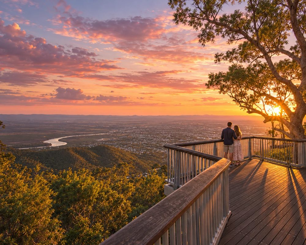
Mount Archer is the forested mountain that forms the backdrop to Rockhampton, rising 604 metres from the edge of the northern suburbs. A sealed road climbs to the summit, where an elevated boardwalk gives one of the best city views in regional Queensland.
Known For
- The Nurim Circuit boardwalk
- Sunset over Rockhampton and the Fitzroy River
- Bush walks from the summit to the suburbs
The national park covers the mountain and the ridges behind it, a mix of open eucalypt forest and patches of dry rainforest in the gullies. It is a few degrees cooler on top than in town.
Things To Do in Mount Archer National Park
Nurim Circuit
From the summit car park at Fraser Park, a 500-metre loop of raised walkway leads out over the western edge of the mountain. The whole of Rockhampton lies below, with the river winding through it, the Berserker Range to the north and, on a clear day, the coast and the Keppel islands to the east. It is fully accessible, and at its best in the last hour of daylight.
Fraser Park
The summit has lawns, picnic shelters, barbecues, a playground and an amphitheatre lookout.
Walking tracks
The Zamia walk descends from the summit through forest and rainforest gullies to the suburbs below, a long one-way walk of several hours that needs a car at each end. Shorter tracks leave from the top and from the base.
Mountain biking
A network of mountain bike trails runs through the foothills on the city side.
Wildlife
Wallabies, glossy black-cockatoos and powerful owls live on the mountain, and wedge-tailed eagles ride the updrafts.
Lookout walks from the summit
Besides the Nurim Circuit, three shorter walks leave Fraser Park. Bracken Fern Way is an easy 1.4 km return stroll of about 45 minutes, the Grasstree Lookout walk is 840 m return, and the Sleipner Lookout walk is about 2.4 km return and takes an hour. The amphitheatre at Fraser Park sometimes hosts yoga or live music, and the adventure playground has totem poles, a trampoline and swings among the trees.
First Turkey mountain bike trails
At the foot of the mountain off German Street, the First Turkey Mountain Bike Reserve has about 30 trails covering close to 30 km, from cross-country loops to gravity and enduro runs with more than 500 metres of descent. The trails are managed with the Rockhampton Mountain Bike Club, are open most days and close after heavy rain.
Where To Stay
There is no camping on the mountain. Stay in Rockhampton.
With no camping in the park, base yourself in North Rockhampton, which is closest to the summit road. Discovery Parks Rockhampton on Yaamba Road at Norman Gardens has cabins, powered sites and a water park, and Riverside Tourist Park sits on Reaney Street by the river in North Rockhampton. The council’s free campground at Kershaw Gardens, off High Street in North Rockhampton, takes fully self-contained vans for up to 48 hours (no tents, no bookings, a maximum of 35 vehicles).
Pilbeam Drive is steep and twisting and not for caravans, so leave the van in town and drive up in the tow vehicle. Across the river, the hotels on Quay Street and Victoria Parade are about 13 km from the summit, among them the Edge Apartment Hotel and Motel 98, both with riverside restaurants. The nearest free dump point is at the Rockhampton Heritage Village in Parkhurst, on the Bruce Highway north of town.
Eat & Drink
Bring a picnic. There are no shops at the summit.
There is no food at the summit, so bring a picnic to the shelters and barbecues at Fraser Park. The closest meals are at the bottom of the mountain in North Rockhampton: Frenchville Sports Club at 105 Clifton Street, about 8 km from the summit, has a bistro and a courtesy bus, and the Berserker Tavern and Glenmore Tavern are nearby local pubs. For a sunset drink after the boardwalk, the Quay Street pubs and the Riverside Precinct are about 13 km away, a 20-minute drive.
History
The mountain is known as Nurim to the Darumbal people. It was named after the Archer brothers, who settled at Gracemere in the 1850s. The national park was declared in 1994.
Getting to Mount Archer National Park
From the north side of Rockhampton follow Frenchville Road and then Pilbeam Drive, which winds five kilometres to the top. The road is steep with tight bends and is unsuitable for caravans.
Experiences
- Active
- City
- Nature based
Popular Activities
- Bird Watching
- Bush Walking
- Mountain Biking
- National Park
- Sightseeing
About Mount Archer National Park
- Locality: Suburb
- Mount Archer National Park Postcode: 4701
- State: Queensland
- Region: Capricorn
- Latitude: -23.3300
- Longitude: 150.5740
- Timezone: Australia/Brisbane
