
Kurnell, NSW
Kurnell is a village on the peninsula that forms the southern headland of Botany Bay, about 35 km from the centre of Sydney. It was here, on 29 April 1770, that James Cook and the crew of the Endeavour first came ashore on the east coast of Australia, and where the Gweagal people first encountered them. The landing place is now part of Kamay Botany Bay National Park.
Known For
- Captain Cook’s landing place
- The meeting of two cultures in 1770
- Whale watching at Cape Solander
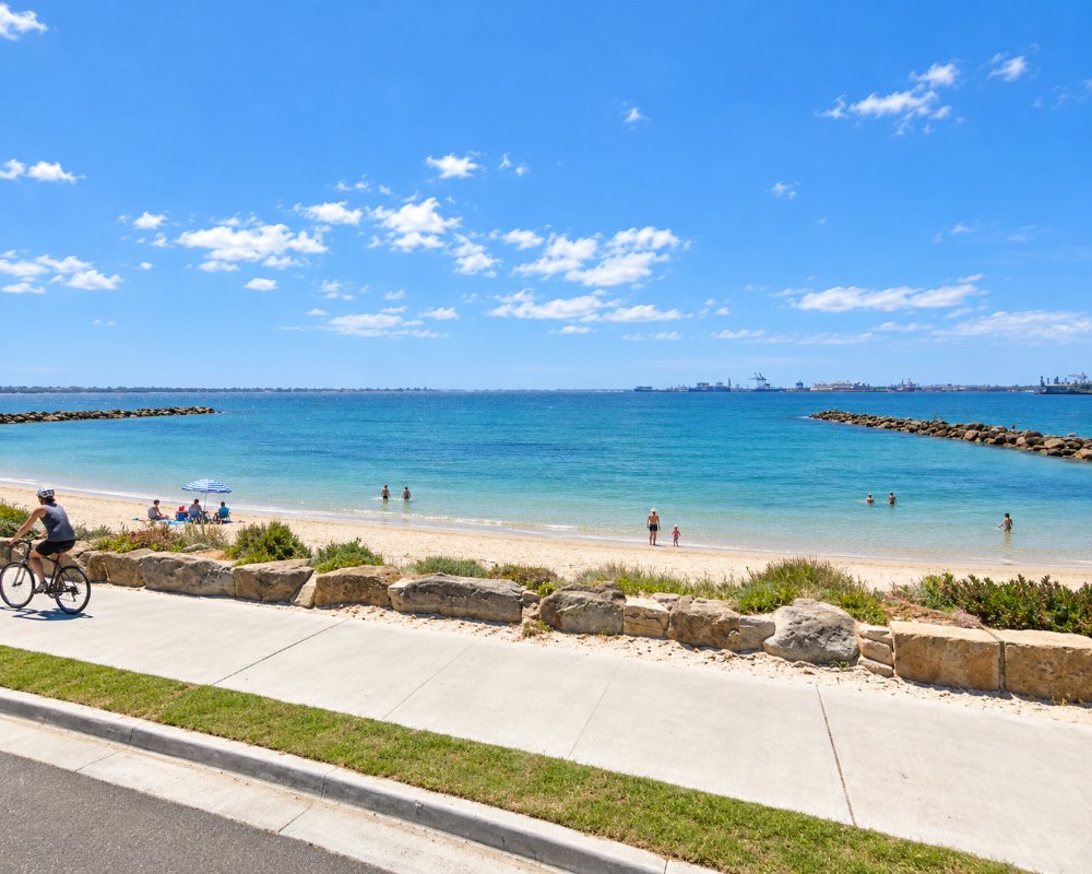
The village is a quiet grid of streets facing the bay, with a beach, a few shops and views across to the airport and the city. Behind it are sand dunes, heath and, on the ocean side, high sandstone cliffs. An industrial area with a former oil refinery and a desalination plant occupies part of the peninsula.
Things To Do
Kamay Botany Bay National Park
The Meeting Place precinct on the bay shore tells the story of the eight days the Endeavour spent here, from both Aboriginal and European perspectives. The Kurnell Visitor Centre is closed while NPWS builds a new one (due to reopen late 2026), but the Burrawang Walk, an easy, wheelchair-accessible loop, passes the landing rock, the Cook obelisk of 1870, monuments to the botanists Joseph Banks and Daniel Solander, and the grave of Forby Sutherland, a seaman who died here. Bronze sculptures installed in 2020, including a set of whale ribs and bark canoes, reflect Gweagal culture.
Cape Solander
On the ocean side of the park, this clifftop lookout is one of the best places in Sydney to watch humpback whales on their northward migration, mainly in June and July. Volunteers count the whales each season.
Coastal Walks
The Cape Baily Track follows the cliffs south past hanging swamps and a lighthouse, with wide ocean views. The Muru and Yena tracks are shorter loops through heath and forest.
Silver Beach
The village beach, lined with stone groynes, is calm and good for swimming, kite surfing and fishing.
Kamay Wharves
Two new wharves, one at Kurnell beside the landing place and one across the bay at La Perouse, opened on 28 February 2025 at a cost of about $78 million. They replace wharves wrecked by storms in 1974, which ended a ferry service that had run since the 1890s, and they are open around the clock for fishing and short stops by boats up to 20 metres. No ferry crosses the bay yet.
Snorkelling and Diving
The rocky reefs at the mouth of Botany Bay are among Sydney’s best shore dives, and NPWS points divers to Inscription Point and the more sheltered Sutherland Point. The waters suit all levels, but check the swell and the boat traffic first.
Silver Beach
Midway along Silver Beach there is a netted swimming enclosure, which is not patrolled. Dogs may run off the lead only between the third and fourth groynes from the western end and are banned on the rest of the beach; access is from Prince Charles Parade.
History
Kurnell is in the country of the Gweagal people of the Dharawal nation, and the name is thought to derive from their name for the peninsula.
When Cook’s party landed, two Gweagal men opposed them and were fired upon. The visitors stayed a week, collecting so many new plants that the bay was named for them. Captain Arthur Phillip arrived here with the First Fleet in January 1788 but judged the site unsuitable and moved to Port Jackson. The landing place was reserved for the public in 1899.
Captain James Birnie took the first land grant, 700 acres, in 1815 and called it Alpha Farm; Thomas Holt bought it in 1860 and tried oyster farming and sheep. A ferry linked Kurnell and La Perouse from the 1890s until 1974, and the headland joined the National Heritage List in 2004. On 16 December 2015 a tornado hit Kurnell with a gust of 213 km/h, the fastest wind recorded in NSW.
Where To Stay
There is little accommodation in Kurnell.
Cronulla, 15 minutes away, has hotels and apartments.
Kurnell has one place to stay: Silverbeach Tourist Park at 284 Prince Charles Parade, with self-contained one-bedroom cabins looking over Botany Bay, an in-ground pool, a coin laundry and secure parking, and a boat ramp 100 metres away. It has no caravan or campervan sites, only cabins. Cronulla, about 10 km south, has Rydges Cronulla Beachside and Quest Cronulla Beach. For caravans, the nearest sites are at the NPWS Bonnie Vale campground at Bundeena in Royal National Park, with powered and unpowered sites, hot showers and flush toilets. Captain Cook Drive is flat and sealed and suits caravans; while the visitor centre is rebuilt, park at the Cricket Pitch and Commemoration Flat areas.
Eat & Drink
The village has a few cafes and takeaways. The national park has picnic areas.
Kurnell is small, but there are cafes near Silver Beach, among them Cook at Kurnell, a beachside brunch cafe known for its burger. The national park has picnic tables at Commemoration Flat and Yena but no food, so bring your own. For supermarkets and fuel, go to Cronulla or Caringbah, about 10 km away.
Milkhouse, a block back from the water on Torres Street, is a retro milk-bar style cafe with empanadas, churros and thick shakes. The visitor centre in the national park is closed while a new one is built.
Getting There
Drive via Captain Cook Drive from Cronulla or Caringbah. A bus runs from Cronulla station. A vehicle entry fee of $8 a day applies in the Kurnell area of the park. New ferry wharves at Kurnell and La Perouse opened in February 2025, but as of late 2026 no ferry operator had been found.
Bus route 987 runs a loop from Cronulla station to Kurnell about every 30 minutes. There is no ferry from La Perouse.
Experiences
- Cultural
- Historic/Heritage
- Nature based
Popular Activities
- Bush Walking
- Fishing
- National Park
- Sightseeing
- Swimming
- Wildlife
About Kurnell
- Locality: Suburb
- Kurnell Postcode: 2231
- State: New South Wales
- Region: Sydney
- Latitude: -34.00849
- Longitude: 151.20488
- Elevation: 5m
- Timezone: Australia/Sydney
