
Greenmount, QLD
Greenmount is a village of about 700 people on the New England Highway, 28 kilometres south of Toowoomba. Low green hills, as the name suggests, roll away on both sides, dotted with dairy and grain farms. It is the first of a string of small settlements that make the drive to Warwick by the back roads one of the most pleasant on the Downs.
Known For
- Steele Rudd’s selection at East Greenmount
- Rolling hills and farm scenery
- The start of a heritage drive through Nobby and Clifton
Things To Do in Greenmount
Steele Rudd memorial
At East Greenmount, a few kilometres off the highway, a park marks the site of the selection where Arthur Hoey Davis spent his childhood in the 1870s and 1880s. Writing as Steele Rudd, he turned his family’s struggles into the stories of Dad and Dave, among the best-loved works of Australian humour. A replica slab hut stands on the site.
Drive the villages
Continue south to Nobby, with its Rudd-themed pub and the grave of Sister Elizabeth Kenny, then on to Clifton and Allora.
The village
Greenmount has a hotel, a store and a memorial hall.
War memorial and parks
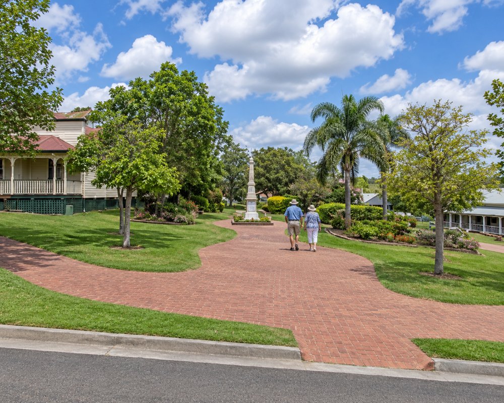
The heritage-listed Greenmount War Memorial stands in Bicentennial Memorial Park on Ramsay Street; it was dedicated in December 1922 by the Governor, Sir Matthew Nathan. The park has a barbecue, a half basketball court and a playground, and Jack Derrick Park on King Street has more play equipment and picnic tables, so the village makes an easy lunch stop if you bring your own food.
The Steele Rudd school
Arthur Hoey Davis went to the Emu Creek State School until he was twelve. Greenmount itself was called Emu Creek, then Greenmount West, before taking its present name from the property of the local farmer and parliamentarian Donald Mackintosh; the post offices swapped names in 1879.
Where To Stay
The hotel may offer rooms; Toowoomba has every kind of accommodation.
There is no caravan park in Greenmount. The Bull & Barley Inn at Cambooya, about 10 km north-west, has pub rooms, and Rudd’s Pub at Nobby, about 12 km south, has accommodation.
For caravans and motorhomes, the closest council stop is the Nobby Town Park Rest Area, across the road from Rudd’s Pub, which allows up to 72 hours in any 7 days and has water, power, toilets, barbecues and a playground. Federation Park at Vale View, closer to Toowoomba, is a 24-hour stop with water and toilets. Two farm stays near Nobby, about 15 minutes away, take small groups: Duchess Farm has a self-contained cabin with room for a caravan or a few tents and welcomes pets, and Carlisle Farm has three grassy campsites under old gums on a working horse property. Clifton Recreation Grounds, about 19 km south, has powered sites, showers and a dump point. Toowoomba, about 30 km north, has every kind of accommodation.
Eat & Drink
Meals are available at the hotel, and the store sells takeaways.
Greenmount is a quiet residential village, so plan meals in the neighbouring towns. The Bull & Barley Inn at Cambooya, about 10 km north-west, serves lunch and dinner seven days, with weekly specials and a Sunday roast. Rudd’s Pub at Nobby, about 12 km south, has a long menu running from morning tea through to dinner every day, served among walls of farm tools and photographs. Clifton, about 19 km south, has two more pubs, the Clifton Arms Hotel and O’Shanley’s Irish Pub, and a railway-station information centre selling local jams. Toowoomba, about half an hour north, has the nearest supermarkets, fuel and the widest choice of cafes and restaurants.
History
Greenmount developed in the 1870s when selectors were allowed to take up small farms on land resumed from the great sheep stations. The railway to Warwick passed nearby.
Getting to Greenmount
Greenmount is on the New England Highway, 25 minutes south of Toowoomba. Cambooya is ten minutes to the north-west.
Experiences
- Historic/Heritage
- Rural/Country
- Self-Drive
Popular Activities
- Cycling
- Driving
- Sightseeing
About Greenmount
- Locality: Rural locality
- Greenmount Postcode: 4359
- State: Queensland
- Region: Southern Queensland Country
- Latitude: -27.77694
- Longitude: 151.89143
- Elevation: 489m
- Population: 699
- Median Income: $34008
- Area (Sq/km): 51.132
- Timezone: Australia/Brisbane
