
Gellibrand, VIC
Gellibrand is a small village in dairy and forest country on the northern side of the Otway Ranges, about 25 km south of Colac and 176 km from Melbourne. It sits on the Gellibrand River, with a general store, a holiday park and a scatter of farms and houses among the hills.
It is a quiet, practical base for the inland Otways: the Otway Fly treetop walk is about 20 minutes away, the waterfalls around Beech Forest are close by, and the Old Beechy Rail Trail passes through the village.
Known For
- Close to the Otway Fly treetop walk
- The Old Beechy Rail Trail
- Blackfish fishing on the Gellibrand River
Things To Do in Gellibrand
Otway Fly Treetop Adventures
About 20 minutes’ drive away near Weeaproinah, the Otway Fly has a 600 m steel walkway 25 to 30 metres up in the rainforest canopy, a 47 m spiral tower and a zipline tour of about two and a half hours. It is open daily except Christmas Day, so just check session times on its booking calendar before you go.
Old Beechy Rail Trail
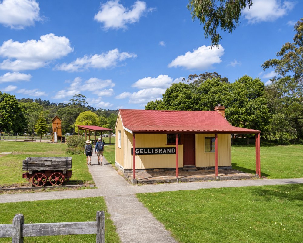
The Old Beechy Rail Trail follows the old narrow-gauge railway from Colac towards Beech Forest. The section from Kawarren to Gellibrand is 6.5 km, and a bridge carries the path over the Gellibrand River, with a historical display in the old station building. Some sections south of Gellibrand, from Wimba to Beech Forest and from Dinmont to Ditchley, are closed until further notice because of timber harvesting, and logging trucks use the forest roads.
Gellibrand River
The Gellibrand River is one of Victoria’s best rivers for river blackfish, and also holds brown trout. It winds through the village and the forest downstream towards Princetown and the sea.
Stevensons Falls
At Barramunga, east of Gellibrand, a walk of about 3.4 km return leads through a stand of Californian redwoods to Stevensons Falls, with a free campground nearby.
Village Life
The village has a pottery, a curio shop and a community market, and the general store doubles as the post office and cafe.
Where To Stay
Otways Tourist Park on Main Road is a well-equipped park of about 60 sites on 3.2 ha, with powered, unpowered and ensuite sites, cabins and a dump point, and it suits caravans of all sizes. It is the best-equipped park in the inland Otways.
Free bush camps nearby include the Carlisle River Reserve on Gellibrand River Road, which has toilets and takes caravans (the water is not drinkable), and Dandos Campground on Lardners Track, which takes caravans and camper trailers. Stevensons Falls has tent sites only. The roads around Gellibrand are sealed but hilly and winding, and logging trucks use some of them.
Otways Tourist Park on Main Road has more than caravan sites: there are deluxe cabins, villas, a spa cabin and motel units, and the park has a solar-heated pool, a camp kitchen, gas barbecues, fire pits and a coin laundry. Dogs are welcome on its pet-friendly sites, with an off-leash area and a pet shower, so it is one of the few inland parks that suits travellers with dogs.
Dandos Campground sits on a bend of the Gellibrand River in the forest south of the village, with about 20 free sites, a separate day area and room for caravans and camper trailers; it is remote, so bring water and everything you need. Lake Elizabeth near Forrest and Stevensons Falls suit tents only. For couples, Redwoods Rest at Beech Forest, about 17 km south, has two cabins with balconies and long views to the coast, and the Johanna Beach Campground below Lavers Hill takes caravans on its 25 unpowered sites.
The sealed Colac-Lavers Hill Road is the best caravan route through the village, and the Otway Fly car park takes vans and motorhomes. Turtons Track, the forest road from Beech Forest across to Skenes Creek Road, is not suitable for caravans or motorhomes.
Eat & Drink
The Gellibrand General Store is also the post office and a cafe, good for coffee, light meals and supplies. The historic Gellibrand River Hotel, from 1888, has a beer garden beside the rail trail, but it has been on the market in recent years, so check it is open before you count on a meal. Colac, 25 km north, has the nearest wide choice of cafes and pubs.
Gellibrand is small, so most visitors pair the village with a meal along the ridge or towards Colac. In summer, Otway Blueberries on the Gellibrand-Carlisle Road has grown pesticide-free fruit since 1994 and opens its farm for pick-your-own from January when the berries are ripe; bring your own containers. The Gellibrand River Market fills Rex Norman Park on Main Road with artisan and food stalls, local musicians and children’s activities on its market Sundays; check the Colac Otway Shire events page for the next one.
About 17 km south, The Beechy Hotel at Beech Forest is a warm country pub with a wood heater, views to the south and a menu of pub classics, burgers, steaks and woodfired pizza. The Otway Fly cafe serves takeaway meals with gluten-free and vegan options until mid-afternoon, and The Perch at Lavers Hill, about 30 km south-west, cooks modern Australian food from local farms and its kitchen garden. On the road north, Otway Estate at Barongarook West has a brewery, cidery and gin distillery, and Colac, about 25 km north, has Hulm’s Bakery, supermarkets and the nearest reliable fuel.
History
This is the Country of the Eastern Maar. Settlers arrived in the 1880s and cleared the forest for dairy farms and orchards, and a butter factory opened in the village. It is named after Joseph Gellibrand, a Tasmanian lawyer who disappeared in the bush of western Victoria in 1837. Gellibrand was a station on the narrow-gauge Colac to Beech Forest railway from 1902 until 1962, fed by timber tramways from the surrounding forest. In January 2026 the Carlisle River bushfire, started by lightning, burned about 11,000 ha of forest and farmland and destroyed at least 16 buildings around Carlisle River and Gellibrand, and the town was evacuated before the fire was brought under control.
Getting to Gellibrand
Gellibrand is about 176 km from Melbourne. From Colac, follow the Colac Lavers Hill Road south for about 25 km. Lavers Hill is about 30 km south-west. There is no public transport; the nearest train station is at Colac.
Experiences
- Active
- Mountain
- Rural/Country
- Self-Drive
Popular Activities
- Bush Walking
- Caravan and Camping
- Cycling
- Fishing
- Mountain Biking
- National Park
- Sightseeing
About Gellibrand
- Locality: Rural locality
- Gellibrand Postcode: 3239
- State: Victoria
- Region: Great Ocean Road
- Latitude: -38.5250
- Longitude: 143.5402
- Elevation: 79m
- Timezone: Australia/Melbourne
