
Moonan Flat and Ellerston, NSW
Moonan Flat is a tiny village on the upper Hunter River, about 50 kilometres north-east of Scone through Gundy. Steep grassy hills close in around it, and the road beyond climbs to Barrington Tops.
Known For
- A much-loved country pub
- The western gateway to Barrington Tops
- The upper Hunter River
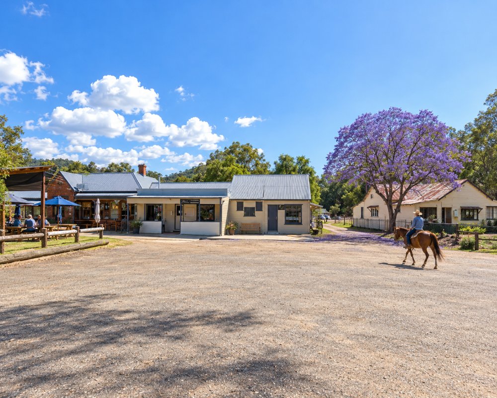
The village is a hotel, a hall, a campground and a few houses beside the river. It is small, friendly and a long way from anywhere.
Things To Do in Moonan Flat
The pub
The Victoria Hotel dates from the gold rush years of the 1850s and 1860s and is the centre of local life. It serves meals and has rooms and cabins.
The pub was listed for sale in 2026, described as tenanted, so phone ahead before counting on a meal or a bed.
Drive to Barrington Tops
Past the village the road turns to gravel, passes through the Dingo Gate and climbs more than 1,000 metres to the plateau. Up there are snow gum woodland, sub-alpine swamps, lookouts and the Polblue camping and picnic area. Snow falls most winters. The road is steep and can be closed by snow or rain, so check conditions and carry chains in winter.
Since June 2025, Upper Hunter Shire has kept a 2.5-tonne gross vehicle limit on a landslip on Barrington Tops Forest Road, which rules out caravans and most loaded four-wheel drives, and the Gloucester end was closed after the May 2025 storms. Check the council and NPWS alerts before setting out.
Polblue and the plateau
Polblue campground, about 24 km past the village and 7 km beyond the Dingo Gate, has 40 unpowered sites with toilets, barbecues and tables. Bring drinking water, a fuel stove and firewood. Feral horses wander through, and the flat Polblue Swamp track is good for kangaroos and wombats early in the morning.
The Firs and Moonan Brook
The road to the Tops follows Moonan Brook past the old Denison Diggings. Further on, The Firs picnic area in Stewarts Brook State Forest sits under tall plantation pines, with lyrebirds scratching among the needles.
Barrington Trail by 4WD
From the plateau, the Barrington Trail is a high-country four-wheel-drive route towards Junction Pools and Mount Barrington, open to vehicles from 1 October to 31 May only.
The river
The Hunter here is a clear, fast stream with trout in the cooler reaches and good swimming holes in summer.
Ellerston
Ellerston, 20 kilometres up the valley, is a locality made up almost entirely of a very large private pastoral and polo property. It is not open to the public, and there is nothing to visit, though the drive is fine.
Where To Stay
Stay at the hotel, at the campground by the river or at farm stays in the valley. National park camping is at Polblue.
Moonan Cottage at Moonan Brook, a restored 1881 school house, sleeps up to 25, and its fenced paddock takes tents and caravans. Book Polblue through NPWS, and note the 2.5-tonne road limit before you tow anything up. Back down the valley, the nearest caravan park is Reflections’ at Lake Glenbawn, about an hour away, with cabins, powered sites and a big area of unpowered lakeside camping, plus a kiosk with fuel.
Eat & Drink
The hotel is the only place for a meal.
Carry food anyway if you are camping on the Tops. The Linga Longa Inn at Gundy, 32 km back towards Scone, serves pub meals, and Scone has supermarkets and fuel. There is no confirmed fuel beyond Gundy.
History
This is the country of the Wonnarua and Geawegal people. Gold was found on Moonan Brook and Stewarts Brook in the mid-1850s, bringing a brief rush.
Nuggets turned up in 1856, and by 1861 the Denison Diggings were busy; the bushranger Captain Thunderbolt robbed two miners there in 1867. The Victoria Hotel building dates from about 1860 and was first licensed as a hotel in 1898. The School of Arts, or Soldiers’ Memorial Hall, opened in 1926, and a suspension footbridge crosses the river.
Getting to Moonan Flat
Moonan Flat is 45 minutes from Scone on a sealed road and about four and a quarter hours from Sydney.
Experiences
- Nature based
- Remote
- Rural/Country
- Self-Drive
Popular Activities
- Bush Walking
- Caravan and Camping
- Driving
- Fishing
- National Park
- Off Road Driving
- Wilderness
About Moonan Flat and Ellerston
- Locality: Village
- Moonan Flat and Ellerston Postcode: 2337
- State: New South Wales
- Region: Hunter
- Latitude: -31.9264
- Longitude: 151.2355
- Elevation: 416m
- Timezone: Australia/Sydney
