
Noosa North Shore and Teewah Beach, QLD
Noosa North Shore is a world away from Hastings Street, though only a short ferry ride separates them. Across the Noosa River from Tewantin, the sealed roads end among paperbark forest, lakes and mobs of kangaroos, and beyond the dunes Teewah Beach runs north for 50 kilometres, a sand highway for four-wheel drives that leads past the coloured sand cliffs to Double Island Point and on to Rainbow Beach.
Known For
- The car ferry across the Noosa River
- Four-wheel driving and camping on Teewah Beach
- The Teewah Coloured Sands and Double Island Point
The North Shore is a low strip of sand country between the river, Lake Cooroibah and the ocean. A few hundred people live here on bush blocks, and there is a holiday park with a bar and bistro, and a large beachfront camping ground. Everything to the north is part of the Cooloola section of Great Sandy National Park, one of the largest coastal wilderness areas in Queensland.
Visitors without a four-wheel drive can still cross on the ferry, see the kangaroos, walk on the beach and have lunch. With one, and the right permits, the whole Cooloola coast opens up.
Things To Do at Noosa North Shore and Teewah Beach
Cross on the ferry
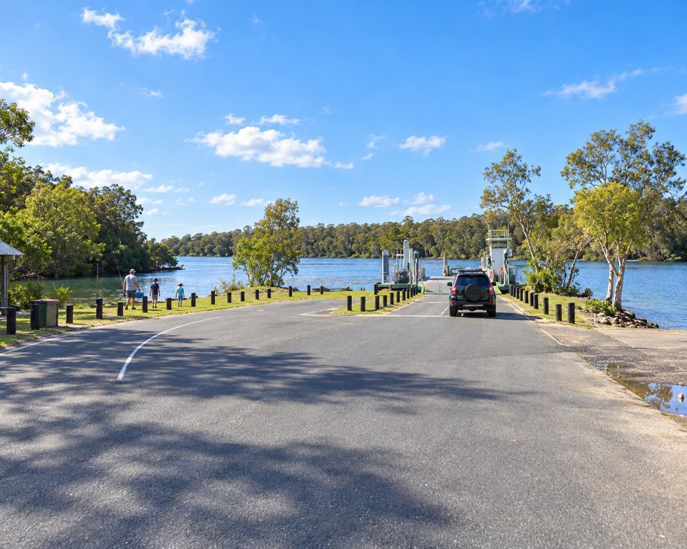
The vehicle ferry leaves from the end of Moorindil Street in Tewantin and takes about five minutes, running from early morning until late evening. A fare is charged each way. On the far side, a sealed road leads to the holiday park and the beach car park, and kangaroos graze on the lawns morning and evening.
Drive Teewah Beach
Beach access tracks lead onto the sand, where normal road rules and a speed limit apply. A vehicle access permit from Queensland Parks is required before driving on the beach, and travel is only sensible within about two hours either side of low tide. From the third cutting it is about 40 kilometres to Double Island Point. Lower your tyre pressures, carry recovery gear and check the tide table.
Teewah Coloured Sands
About halfway along the beach, cliffs up to 200 metres high are streaked with reds, yellows, browns and whites, stained over thousands of years by iron and other minerals. In a Kabi Kabi story the colours came from a rainbow spirit killed in a fight over a woman. The colours are strongest in the early morning light and after rain.
Double Island Point
At the northern end, a headland with a lighthouse gives views up and down the coast, and its sheltered side has a long, peeling surf break and a calm lagoon. Turtles, dolphins and manta rays are often seen from the lookout, and whales in season. From here a sand track crosses to Rainbow Beach.
Camping, fishing and riding
The Teewah Beach camping zone stretches for about 15 kilometres behind the dunes, with no facilities; campers bring everything, including a toilet, and need a permit. The beach is one of the best in the state for tailor in winter, along with dart, whiting and bream. On the North Shore itself, horse rides along the beach and through the bush can be booked.
Teewah camping zones and toilets
Queensland Parks now divides Teewah Beach camping into seven numbered zones of different lengths, each booked separately. Every camper needs a portable toilet with a sealed holding tank (bag-and-bucket types are not allowed), and the waste must be emptied at the beach camper facility opposite the Freshwater day-use area. Deep holes in the lagoon at Double Island Point can also block the beach route to Rainbow Beach, so check the park alerts.
Where To Stay
Noosa North Shore Beach Campground, run by the council, has powered and unpowered sites behind the dunes, a few minutes’ walk from the surf, and can be reached in an ordinary car.
Nearby, a bushland retreat offers cabins, villas and glamping tents with pools and a bistro, and there are holiday houses for rent. Further north it is beach camping only. For hotels and apartments, Noosaville is 15 minutes from the ferry.
Noosa North Shore Beach Campground is run for Noosa Council by Escape Parks, with powered and unpowered sites behind the dunes and four-wheel-drive access straight onto the beach. The bushland retreat is now BIG4 Park Lane Noosa North Shore, with glamping tents, cabins and powered sites around the North Shore Pavilion. Senses Noosa North Shore has self-contained houses on 40 acres of bush with pools and a spa, a short walk from the beach.
The car ferry has been run for the council by a new operator since July 2024, with cashless payment, and runs about every ten minutes from early morning to late evening. Caravanners should stock up in Tewantin before crossing.
Eat & Drink
The North Shore Pavilion at BIG4 Park Lane Noosa North Shore, about 5 km from the ferry, has a cafe, a bar and bistro, a bottle shop and a small general store, all open to day visitors. Beyond that there is nothing until Rainbow Beach, so bring food, drinking water and fuel for a trip up the beach.
Across the river, the Royal Mail Hotel and the restaurants of Noosa Marina are about 2 km from the Tewantin ferry landing.
History
The Cooloola coast is the country of the Kabi Kabi people. Timber-getters worked the forests behind the dunes from the 1860s, and in 1973 the cargo ship Cherry Venture was driven ashore near Double Island Point, where its rusting hull was a landmark until it was removed in 2007. Plans to mine the dunes for mineral sands were defeated in the 1970s after a national campaign, and Cooloola became a national park in 1975.
Getting to Noosa North Shore and Teewah Beach
Drive to Tewantin, about ten minutes from Noosa Heads, and follow the signs to the ferry. Several operators run four-wheel-drive day tours up the beach from Noosa for those without their own vehicle. Vehicle and camping permits are sold online by Queensland Parks.
Experiences
- Caravan and Camping
- Nature based
- Remote
- Soft Adventure
Popular Activities
- Beach
- Caravan and Camping
- Fishing - Beach
- Horse Riding
- National Park
- Off Road Driving
- Wildlife
About Noosa North Shore and Teewah Beach
- Locality: Rural locality
- Noosa North Shore and Teewah Beach Postcode: 4565
- State: Queensland
- Region: Sunshine Coast
- Latitude: -26.33223
- Longitude: 153.04550
- Elevation: 5m
- Timezone: Australia/Brisbane
