
Whitsunday Island and Whitehaven Beach, QLD
Whitsunday Island is the largest of the 74 Whitsunday islands and the one almost every visitor sees, because its eastern shore is Whitehaven Beach, seven kilometres of brilliant white sand that regularly appears on lists of the best beaches in the world. The island has no resort, no roads and no residents. All of it is national park, with rainforested peaks, deep sheltered harbours and a string of small beach camping areas.
Known For
- Whitehaven Beach, seven kilometres of pure white silica sand
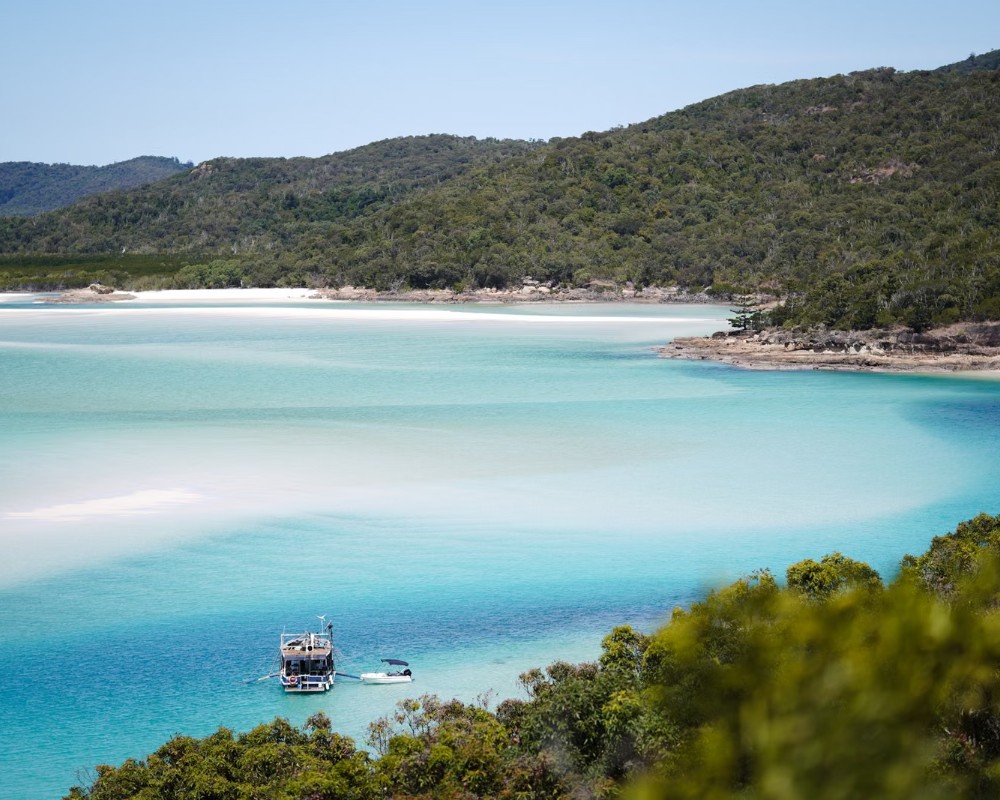
- The swirling sands of Hill Inlet from the Tongue Point lookouts
- Bush camping, walking tracks and quiet anchorages in a national park
The island covers about 275 square kilometres and rises to Whitsunday Peak, 437 metres above the sea. Hoop pines stand along the ridges, vine forest fills the gullies and mangroves line the inlets. To the north a narrow channel divides it from Hook Island; to the south-west lies Hamilton Island, only a few kilometres away. Smaller national park islands sit close by, among them Border Island and Haslewood Island to the east and Henning Island to the south-west.
Most people come for the day by boat, seaplane or helicopter from Airlie Beach or Hamilton Island, spending a few hours on the sand and at the lookout. Those who stay longer, on a yacht or in a tent, find that the day boats leave by mid-afternoon and the beach is close to empty at dawn and dusk.
Things To Do on Whitsunday Island
Whitehaven Beach
The sand at Whitehaven is about 98 per cent silica, so fine that it squeaks underfoot and so pale that it stays cool on the hottest day. The water is shallow and clear, shading from white to turquoise. Most tours land at the southern end, where there are picnic tables, toilets and shade among the trees; walk north for ten minutes and the crowds thin quickly. There are no shops or bins, so everything carried in must be carried out.
Hill Inlet and Tongue Point
At the northern end of the beach, the tide moves through Hill Inlet and spreads the white sand into shifting patterns of blue and green. The view from above is the most photographed scene in the Whitsundays. Boats land at Tongue Bay, and a walking track of about 1.3 kilometres return climbs to three lookout platforms, then drops to Bettys Beach and the edge of the inlet, where small rays and lemon sharks cruise the shallows. The patterns are clearest around low tide.
Walks at the southern end
From the southern end of Whitehaven, a short track climbs to South Whitehaven Lookout for a view along the whole beach, and the Solway Circuit loops through the forest behind it. A longer track crosses the headland to Chance Bay, a pair of quiet beaches facing south towards Hamilton Island, about seven kilometres return.
Whitsunday Peak and Cid Harbour
On the western side of the island, Cid Harbour is a large, calm anchorage used by yachts in all weather. From Sawmill Beach a steep track climbs through rainforest to Whitsunday Peak, about five kilometres return, with views over the whole island group, and an easier path follows the shore to Dugong Beach. Swimming is not recommended anywhere in Cid Harbour, where there have been serious shark attacks; signs at the beaches explain the warning.
Camping
Queensland Parks has camping areas at the southern end of Whitehaven Beach, Chance Bay, Dugong Beach, Naris Beach, Joes Beach and Cairn Beach, each with a toilet and a few sites but no drinking water. Permits must be booked well ahead for school holidays. A camping transfer boat from Shute Harbour carries campers, water containers and hired kayaks, and several beaches are linked by the Ngaro Sea Trail, a route for sea kayakers.
The Ngaro Track
Opened in April 2026, the Ngaro Track is a 32 km walk across Whitsunday Island over three days and two nights, from the southern end of Whitehaven Beach via Chance Bay and a 353-metre summit to the Hill Inlet lookouts, with a boat pick-up at Tongue Bay. Walkers need a booking to use the track and its two hikers’ camps, and numbers are capped at about 15 a day. Independent permits for 2026 sold out, and bookings for the 2027 season (best from April to October) are now open; guided and catered trips are also sold. Walkers carry all their food, a tent and a personal locator beacon, and the track cannot be walked as a day walk.
Where To Stay
There is no accommodation on Whitsunday Island other than the national park camping areas, where campers must bring a tent, a fuel stove and at least five litres of water per person per day.
Everyone else visits from a base nearby. Hamilton Island is the closest, about 30 minutes by fast boat from Whitehaven, and Airlie Beach has the widest choice of hotels, apartments and hostels. Overnight sailing trips from Airlie Beach anchor off the island, usually in Tongue Bay or Cid Harbour.
Camping permits are booked online through Queensland Parks and Wildlife, up to 11 months ahead. The Whitehaven Beach camping area has 10 sites, one of them a group area, and there are no caravan or camper-trailer sites anywhere on the island; campfires are not allowed. The camping transfer is Scamper (Whitsunday Island Camping Connections), which leaves Shute Harbour, about 10 km south-east of Airlie Beach. It usually makes one trip a day timed for the high tide, hires full camping kits and snorkel gear, carries sea kayaks for Salty Dog Sea Kayaking, and closes for about a month from mid-February. Ngaro Track walkers sleep at two purpose-built camps, Bowarri yamba (Moon Camp) and Dhula yamba (Tree Camp), which only track walkers may use.
For a night on the water, overnight sailing trips from Airlie Beach include True Blue Sailing’s Atlantic Clipper and New Horizon (aimed at travellers aged 18 to 35), OzSail’s Avatar and Mandrake, and Explore Whitsundays’ Prima, Waltzing Matilda and the tall ship Solway Voyager. Bareboat yachts, which need no licence, are hired from Whitsunday Escape, Cumberland Charter Yachts and Charter Yachts Australia. On the mainland, Coral Sea Resort sits beside Coral Sea Marina, and Harbour Cove Resort and Boathouse Apartments are a short walk from the Port of Airlie terminal. Caravanners can stay at parks in Airlie Beach and Cannonvale, such as BIG4 Adventure Whitsunday Resort.
Eat & Drink
There is nothing to buy on the island. Day tours include lunch and drinking water, and many serve it on the beach. Campers and private boats need to bring all supplies and take their rubbish away. Glass is best left behind, and food should be kept away from the goannas and gulls that patrol the picnic area.
There is still no food for sale anywhere on Whitsunday Island, so what you eat depends on the tour. Cruise Whitsundays’ Chill & Grill day cooks a barbecue on the beach at Whitehaven, its Purely Whitehaven cruise serves a buffet lunch on board, Red Cat Adventures’ Thundercat includes a buffet lunch, and ZigZag Whitsundays’ catamaran Super Flyer has a licensed bar. Ngaro Track walkers carry all their food and at least 3 litres of water a day. Before or after a trip, the nearest cafes are at the Airlie Beach marinas: Zorro’s Cafe & Bar and Rufus and Co. Café at the Port of Airlie, and Le Kiosk Cafe & Bar at Coral Sea Marina.
History
The island is at the centre of the sea country of the Ngaro people, who lived on these islands for at least 9,000 years, travelling by bark canoe and leaving middens, fish traps and rock art. Captain James Cook sailed through the passage on the western side in June 1770 and named it Whitsunday Passage, believing the day to be Whit Sunday.
Hoop pine was cut on the island from 1861, when a logging camp was set up to supply the new town of Bowen, and later milled at Cid Harbour, which is how Sawmill Beach got its name. During the Second World War the harbour was used as an anchorage for Allied warships. The island became national park, and Whitehaven’s fame grew with the day-cruise fleets from the 1980s onwards.
Getting to Whitsunday Island
Day cruises, fast rafts and sailing boats run to Whitehaven Beach and Hill Inlet every day from the Port of Airlie and Coral Sea Marina at Airlie Beach, about an hour and a half away, and from Hamilton Island. Seaplanes and helicopters fly from Whitsunday Airport near Airlie Beach and from Hamilton Island, landing beside the beach. Campers use the transfer boat from Shute Harbour. Stinger suits are advised from about October to May and are supplied by tour boats.
Experiences
- Eco Tourism
- Island
- Nature based
Popular Activities
- Beach
- Bush Walking
- Caravan and Camping
- National Park
- Sailing
- Scenic Flight
- Snorkelling
- Swimming
About Whitsunday Island and Whitehaven Beach
- Locality: Island
- Whitsunday Island and Whitehaven Beach Postcode: 4802
- State: Queensland
- Region: The Whitsundays
- Latitude: -20.2820
- Longitude: 149.0390
- Timezone: Australia/Brisbane
