
Wilcannia, NSW
Wilcannia is a small town on the Darling River, on the Barrier Highway about 195 km east of Broken Hill and 950 km from Sydney. In the 1880s it was the third-largest inland port in Australia, known as the Queen City of the West, and it still has a remarkable collection of sandstone buildings from that era. Today it is a largely Aboriginal town and the heart of Barkindji country.
Known For
- Sandstone buildings from the river-port era
- The Darling River, or Baaka
- Barkindji culture and art
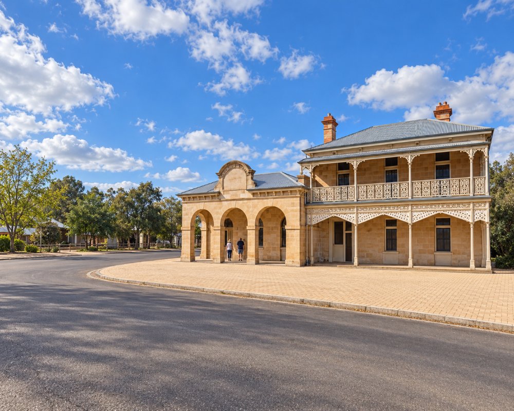
About 700 people live in Wilcannia, most of them Barkindji, whose name means people of the river. The Darling, which they call the Baaka, loops around the town between high banks lined with river red gums. Many travellers pass through without stopping, which is a pity, as a walk around the old centre is rewarding.
Things To Do
Heritage Trail
A signposted walk takes in the courthouse, police station and gaol, all designed in the 1880s by the colonial architect James Barnet and built of local sandstone, along with the post office, the Athenaeum library, old banks, stores and the Club Hotel.
Centre-Lift Bridge
The iron bridge over the Darling, opened in 1896, has a central span that was raised to let paddle steamers through. It stands beside the modern highway bridge and can be walked across.
The Old Wharf
Remains of the wharf and the wool store on the river bank recall the years when up to ninety steamers a season loaded wool here.
Art and Culture
Local artists produce paintings, carvings and prints, shown at galleries and an arts centre in town. The Baaka Cultural Centre, in the restored Knox and Downs store on Reid Street, was finished in 2024 and is due to open officially in 2026.
White Cliffs and Paroo-Darling
The opal-mining town of White Cliffs, where people live underground, is 95 km north on a sealed road. Paroo-Darling National Park, to the north-east, protects lakes and river country.
History
Wilcannia is in the country of the Barkindji people.
Thomas Mitchell passed along the river in 1835. The first paddle steamer came up the Darling in 1859, the town was proclaimed in 1866, and by the 1880s it had about 3,000 people, thirteen hotels and its own newspaper. The railway to Broken Hill bypassed it, the river trade ended, and the town declined through the twentieth century.
Where To Stay
There is no motel in Wilcannia at present, so most travellers stay at the two caravan parks by the river just outside the centre. Victory Caravan Park, run by Central Darling Shire on the bank of the Darling, has powered and unpowered sites for vans, tents and buses, a new amenities block with an accessible bathroom and free washing machines, and dogs are welcome on a lead. Warrawong on the Darling, about 3 km east on the highway, has cabins, studio rooms and bush camping beside the river, with campfires allowed.
There are station stays in the district. White Cliffs, about 95 km north, has more beds, including underground rooms, Broken Hill, about 196 km west, has the widest choice of motels and caravan parks, and Cobar, 260 km east, is the next big stop towards Sydney.
Caravans and Camping
Wilcannia was declared an RV Friendly Town in 2025. Victory Caravan Park, the council park on the bank of the Darling, reopened in 2024 with a new amenities block and has powered and unpowered sites that are booked online. Under the RV Friendly Town scheme, self-contained rigs can stay up to 96 hours on an unpowered site, and long rigs can park in Reid Street near the post office and Baker Park while you look around town. A free dump point and drinking water tap are outside the oval in Myers Street. The Barrier Highway and the road to White Cliffs are sealed; the river roads are not.
Eat & Drink
Food in Wilcannia is basic and hours are short, so arrive with supplies. The Wilcannia Golf Club is the town’s licensed club, with a bar and a kitchen, weekly bingo, trivia and meat raffles, and a courtesy bus on Wednesday to Saturday evenings; the club is closed on Monday and Tuesday, so check meal times when you arrive. Takeaway food and groceries are sold in the main street, but there is no bakery, so buy bread in Broken Hill or Cobar. Fuel, including diesel, is sold at two outlets in town, so fill up before dark. White Cliffs, 95 km north, has a pub and a general store with takeaway. Between Wilcannia and Cobar there is very little, so carry water and snacks on that 260 km stage, and for a full shop, Broken Hill has supermarkets, bakeries and cafes.
The golf club stands on the site of the first Resch’s brewery, from the days when Wilcannia was a busy river port, and its walls are hung with old photographs; bingo is on Saturday afternoons. No hotel in town is trading. Three kilometres east on the Barrier Highway, Warrawong on the Darling, a caravan park with cabins on the riverbank, now has a cafe serving meals daily.
Getting There
Wilcannia is on the Barrier Highway, about two hours from Broken Hill and 260 km west of Cobar. The river roads to Menindee, Tilpa and Louth are unsealed.
From Sydney, Wilcannia is reached by sealed highway all the way: the Great Western Highway to Bathurst, the Mitchell Highway through Dubbo to Nyngan, then the Barrier Highway through Cobar. The whole route suits caravans; allow two long days or three easy ones. The Cobb Highway from Hay and Ivanhoe, sealed all the way since 2023, joins the Barrier Highway at Wilcannia.
Experiences
- Cultural
- Historic/Heritage
- Remote
- Self-Drive
Popular Activities
- Caravan and Camping
- Fishing
- Outback
- Sightseeing
About Wilcannia
- Locality: Rural locality
- Wilcannia Postcode: 2836
- State: New South Wales
- Region: Outback NSW
- Latitude: -31.557
- Longitude: 143.378
- Elevation: 78m
- Timezone: Australia/Sydney
