
Yorketown, SA
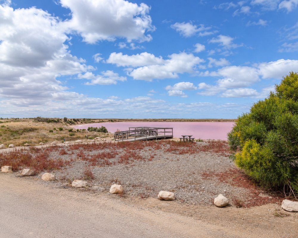
Yorketown is the main service town of southern Yorke Peninsula, about 230 km by road from Adelaide. It lies a little inland, surrounded by grain farms and by more than 200 salt lakes, which once supported a thriving salt industry and which turn shades of pink in the right conditions.
Known For
- Salt lakes that turn pink
- The service centre of the southern peninsula
- Easy access to both coasts
Five roads meet at the centre of town, and most of the southern peninsula’s beach towns are within half an hour, and the furthest about 50 minutes: Edithburgh and Stansbury to the east, Point Turton to the west and Marion Bay to the south-west. Yorketown has the district hospital, banks, supermarkets and the area school.
Things To Do
Salt Lakes
The shallow lakes around the town fill with winter rain and dry to a white crust in summer. Algae and bacteria in the salty water can colour some of them pink, most often as the lakes dry out over the warmer months. A signposted lake trail leads to viewing points close to town. Colours vary with the season and weather, so nothing is guaranteed.
Salt Lake Art
A Y-shaped viewing platform built in 2024 runs 75 metres out onto Pink Lake, and a painted water tank on the Salt Lake Trail and the mural on the town’s water tower make good subjects for photographs.
Historical Museum
The local historical society’s collection includes photographs and equipment from the salt-scraping days, when the crust was shovelled into heaps by hand and carted by horse tram to the port at Edithburgh.
St Columba’s Church
This Catholic church on Warooka Road is among several stone churches in the town.
YP Salt Lake Trail
The signposted lake trail is a self-drive route with four colour-coded, numbered options, from a short loop near town to a longer drive past dozens of lakes. It starts at Weaners Flat Reserve on Stansbury Road, where a signboard beside Par Lake explains each route and the history of salt scraping. Winter brings full lakes and reflections, spring draws waterbirds, autumn mornings are often foggy, and summer leaves dry lake beds in pink, orange and white.
Heritage Walk and Visitor Information
The Historical Society’s heritage walk takes in the town’s notable buildings, including the Old Courthouse, which holds more than 1000 photographs of the pioneering years. Pick up a walk map, along with brochures for the south of the peninsula, at the visitor information outlet in the Southern Yorke Peninsula Community Hub on Stansbury Road.
Lights at the Lake
For Christmas 2026 Yorketown is holding Lights at the Lake, a community celebration lit by handmade lanterns built by local residents. Check local notices for the date and time.
History
Yorketown is on Narungga country.
The site was first called Weaners Flat, as pastoralists used it for weaning lambs. The town was surveyed in 1872 and took its name from the peninsula, which Matthew Flinders had named in 1802 after Charles Yorke, a British politician. Salt was harvested commercially from the 1870s, and for decades the lakes supplied a large share of Australia’s salt. The industry wound down after the Second World War.
Where To Stay
Yorketown has a caravan park and the Melville Hotel.
The Yorketown Caravan Park is in Memorial Drive and has the town’s dump point, which non-guests can use for a fee. There is no free camping in the town. The nearest council bush campgrounds are on the south coast at Sturt Bay, Mozzie Flat, Goldsmith Beach and Wattle Point, and need a permit bought online.
Most holidaymakers stay on the coast at Edithburgh, Stansbury or Point Turton, all within 25 minutes.
The council-run Yorketown Caravan Park, a short walk from the shops, has lawned and hardstand powered sites, drive-through sites for long rigs, two-bedroom ensuite cabins and barbecues in garden surrounds. It makes a quiet, central base for the salt lakes and the south coast, and its dump point is on site.
The Melville Hotel on Minlaton Road has pub rooms in the centre of town. For a holiday house, Accommodation on Yorkes, a local agency on Minlaton Road, manages about 140 privately owned homes from Moonta Bay to Marion Bay, so it is a useful first call for a family stay at Edithburgh, Coobowie or Stansbury.
Edithburgh, 16 km east, has a foreshore caravan park with cabins, a 16-unit motel and hotel motel units, and Coobowie and Stansbury both have caravan parks close to the water. Point Turton Caravan Park is about 35 km west past Warooka.
On the south coast, about 20 km south of town, the council’s small Mozzie Flat bush campground sits near the Port Moorowie boat ramp. The ramp was closed by storm damage in May 2025 and repairs began in October 2025, so check that it has reopened before towing a boat down. Council bush camping permits cost about $20 a night per vehicle and must be bought online before you set up.
Eat & Drink
The Melville Hotel serves meals, and the Foodland supermarket and the main-street shops cover supplies, making this the best place to stock up before heading to the far south of the peninsula.
The Melville Hotel on Minlaton Road, known locally as the Melly, was brought back to life in 2019 by a couple who had first run it in the 1990s. It serves modern Australian pub meals with vegan, dairy-free and gluten-free choices, and its monthly community raffle raises money for local causes. Yorketown Foodland on Warooka Road is the place to stock up before heading on to Marion Bay, Innes or the bush camps.
There is more within a short drive. In Edithburgh, 16 km east, the Troubridge Hotel serves lunch and dinner daily, with local seafood and a Wednesday schnitzel night. At Stansbury, about 20 km north-east, the Dalrymple Hotel faces the foreshore and mixes modern Australian dishes with pub classics, and Lost Tide Spirit Co makes small-batch spirits on Anzac Parade. At Warooka, 24 km west, Lower Yorke Seafood and Salt Food and Events sells locally caught seafood to eat in, take away or cook at home, and the Warooka Hotel, built in 1877, serves country pub meals. The Edithburgh Community Market runs on the second Sunday of each month.
Fuel stations on the southern peninsula often close early or keep short weekend hours, so fill up before heading further south.
Getting There
From Adelaide, follow the Yorke Highway through Ardrossan and Minlaton, a drive of about two and a half hours. Yorketown is 16 km from Edithburgh and 70 km from Marion Bay.
Experiences
- Caravan and Camping
- Historic/Heritage
- Rural/Country
- Self-Drive
Popular Activities
- Bird Watching
- Caravan and Camping
- Driving
- Sightseeing
About Yorketown
- Locality: Urban locality
- Yorketown Postcode: 5576
- State: South Australia
- Region: Yorke Peninsula
- Latitude: -35.01906
- Longitude: 137.60534
- Elevation: 27m
- Timezone: Australia/Adelaide
Accommodation In Yorketown
Discover some of the accommodation in and around Yorketown
