
Bodallin, WA
Bodallin might be a small dot on the map, but its significance stretches back over a century. Situated in Western Australia’s Wheatbelt, this town lies 323 kilometers east of Perth, making it a 3.5-hour drive along the Great Eastern Highway. As you journey toward Bodallin, you’re not just traveling through the heart of WA’s agricultural landscape—you’re stepping into a space rich in history and community spirit.
Known For
- Its connection to the Golden Pipeline Heritage Trail
- Historical landmarks like Bodallin Soak and Railway Dam
- Proximity to expansive Wheatbelt agricultural lands
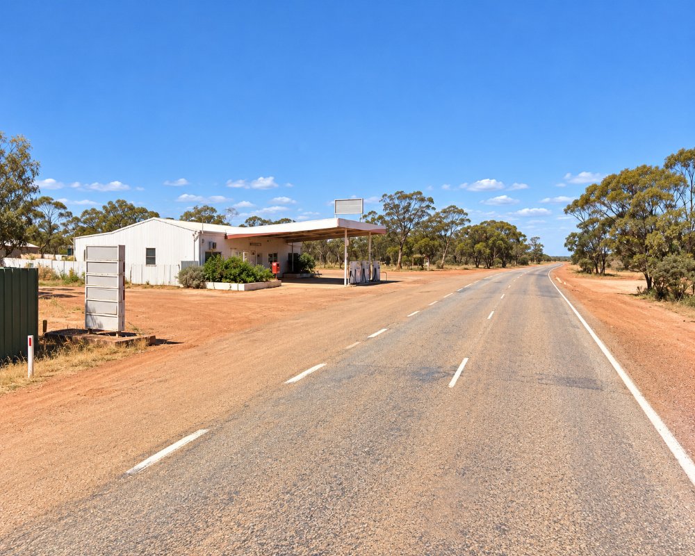
Bodallin sits on the Great Eastern Highway in the Shire of Yilgarn, roughly halfway between Merredin, about 65 km west, and Southern Cross, about 47 km east. Carrabin is about 15 km west and Moorine Rock about 25 km east, and Westonia, off the highway to the north-west, has the nearest caravan park.
The town’s modest yet vital amenities include a general store and post office, ensuring that residents and visitors have access to everyday essentials. These simple conveniences echo the charm of Bodallin: unpretentious and rooted in a sense of community.
Things To Do in and around Bodallin
Railway Dam and Pioneers Park
A trip to Bodallin offers more than a glimpse of history. The Bodallin Railway Dam, located just west of the town, serves as both a historical landmark and a tranquil spot for picnicking. Nearby, Pioneers Park provides travelers with a family-friendly space to relax and recharge.
The Golden Pipeline
Another highlight is Bodallin’s inclusion on the Golden Pipeline Heritage Trail. This self-guided drive trail showcases the engineering marvels of WA’s water supply system while weaving through towns steeped in gold mining history. Bodallin serves as a quiet, reflective pause along this journey, where past and present meet seamlessly.
About 10 km west, the No. 5 pumping station at Yerbillon is a Golden Pipeline Heritage Trail site, with house sites, old fruit trees and Arbor Day trees marking the pump-station school, which opened in 1908 and took children from Bodallin and Carrabin, who rode in the guard’s vans of goods trains.
Boodalin Soak
The soak that gave Bodallin its name is about 6 km west of Westonia, reached from Stoneman Road. Hunt built it in 1865 as one of 26 wells between York and the Hampton Plains, and it became a watering stop on the way to the goldfields. It is a day-use area only, with no camping and no pets because of baiting.
Edna May Mine Lookout
In Westonia, a lookout off Warrachuppin Road looks into the working Edna May open-pit gold mine, which dates from 1911, and visitors can sometimes watch a blast. Westonia’s restored main street and Hood-Penn Museum are close by.
Moorine Rock and Frog Rock
About 25 km east, Moorine Rock grew around a camp on the telegraph line in 1892, and a large 1890s railway dam still stands at the east end of town. Nearby Frog Rock is a wave-shaped granite with a dam at its base and spring wildflowers.
Where To Stay
While Bodallin itself offers limited accommodations, nearby towns like Southern Cross and Merredin provide an array of options, from comfortable motels to caravan parks. For road-weary travelers, the Bodallin Roadhouse is a convenient spot to refuel—both your vehicle and your energy—with hearty meals and refreshments.
Bodallin Roadhouse on the highway sells fuel, and the sealed Great Eastern Highway runs right through. For a powered site, Westonia Shire Caravan Park is about 30 km west, Southern Cross Caravan Park about 55 km east, and Merredin Tourist Park, with a dump point, about 60 km west.
Bodallin has no caravan park or motel. Westonia Shire Caravan Park has powered sites on concrete pads, tent sites, single-bed units and an overflow area for big rigs and fifth-wheelers, St Luke’s Church in Westonia offers a free 48-hour stop for fully self-contained RVs, a free dump point is on Boodarockin Road, and the Westonia Tavern and Motel has 14 ensuite rooms.
To the east, Southern Cross Caravan Park and Sandalwood Motor Lodge on Coolgardie Road has 60 sites, including drive-through bays, plus rooms, cabins and motel units, and Southern Cross has a free dump point at the end of Achernar Street. The Moorine Rock Hotel also has rooms.
Eat & Drink
The Bodallin Roadhouse on Corboy Street covers fuel, the general store and post office, and is the only food stop in town. In Westonia, the community-owned Co-op and Cafe has salads, hot lunches and groceries on weekdays and Saturday morning, the Westonia Gallery Cafe serves coffee and Devonshire and high teas, and the tavern does dinner every day.
In Southern Cross, the Palace Hotel serves dinner every night, the Club Hotel on Antares Street does lunch and dinner, the Railway Tavern has pizzas and a Sunday roast, and two roadhouses on the highway are open around the clock.
History
Bodallin’s story begins in 1865 with the creation of the Bodallin Soak by Charles Hunt. Originally intended as a freshwater resource for livestock and early settlers, the soak became an indispensable water source for gold prospectors. By the late 19th century, the establishment of a railway siding solidified Bodallin’s place as a waypoint for travelers and traders alike.
The official gazettal of Bodallin in 1918, with its name adjusted in 1947, marked a new chapter. Post-World War I, the land surrounding Bodallin was opened for agricultural development, particularly for returning soldiers. Today, the town stands as a reminder of resilience and adaptability in the face of changing times.
Bodallin lies on the country of the Njaki Njaki Noongar people, and the name probably comes from Boodalin, the Aboriginal name of the soak north-west of the siding, which one source translates as a big round soak. The railway siding was set up in the 1890s with a dam for the engines, and a baker’s oven from that time survives. Robert Rankin built the Railway Hotel in 1897, and the townsite was gazetted in 1918 under the spelling Boddalin, which was corrected in 1947.
Getting to Bodallin
Reaching Bodallin is straightforward. By car, the Great Eastern Highway offers a scenic route from Perth, cutting through the Wheatbelt’s vast, open landscapes. For those preferring public transport, the Prospector train service makes Bodallin accessible, stopping on request, if booked ahead, on its daily journey between East Perth and Kalgoorlie.
The Great Eastern Highway is sealed, fine for caravans and shared with road trains, and Kalgoorlie is about 270 km further east. Merredin and Southern Cross are regular train stops.
The journey to Bodallin is as much about the road as it is about the destination. Rolling fields of wheat, expansive skies, and the occasional kangaroo sighting make for an experience that feels authentically Western Australian.
Experiences
- Historic/Heritage
- Rural/Country
- Self-Drive
Popular Activities
- Caravan and Camping
- Driving
- Sightseeing
About Bodallin
- Locality: Rural locality
- Bodallin Postcode: 6424
- State: Western Australia
- Region: Esperance & the Golden Outback
- Latitude: -31.37055
- Longitude: 118.85149
- Elevation: 373m
- Population: 53
- Median Income: $39624
- Area (Sq/km): 744.34
- Timezone: Australia/Perth
